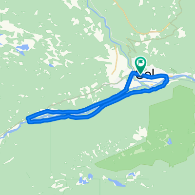
Golsfjellet - Vinstervannet - Tyin - Golsfjellet
A cycling route starting in Gol, Buskerud, Norway.
Overview
About this route
- 20 h 13 min
- Duration
- 269.1 km
- Distance
- 4,077 m
- Ascent
- 4,076 m
- Descent
- 13.3 km/h
- Avg. speed
- 1,296 m
- Avg. speed
Route quality
Waytypes & surfaces along the route
Waytypes
Quiet road
114.2 km
(42 %)
Road
43.6 km
(16 %)
Surfaces
Paved
31.8 km
(12 %)
Unpaved
146.2 km
(54 %)
Gravel
139.6 km
(52 %)
Asphalt
31.5 km
(12 %)
Continue with Bikemap
Use, edit, or download this cycling route
You would like to ride Golsfjellet - Vinstervannet - Tyin - Golsfjellet or customize it for your own trip? Here is what you can do with this Bikemap route:
Free features
- Save this route as favorite or in collections
- Copy & plan your own version of this route
- Sync your route with Garmin or Wahoo
Premium features
Free trial for 3 days, or one-time payment. More about Bikemap Premium.
- Navigate this route on iOS & Android
- Export a GPX / KML file of this route
- Create your custom printout (try it for free)
- Download this route for offline navigation
Discover more Premium features.
Get Bikemap PremiumFrom our community
Other popular routes starting in Gol
- Gol Round 3
- Distance
- 20.9 km
- Ascent
- 824 m
- Descent
- 824 m
- Location
- Gol, Buskerud, Norway
- Einarsetrunden Storefjell
- Distance
- 12.7 km
- Ascent
- 0 m
- Descent
- 0 m
- Location
- Gol, Buskerud, Norway
- Tisleidalen rundt på Golsfjellet
- Distance
- 41.5 km
- Ascent
- 0 m
- Descent
- 0 m
- Location
- Gol, Buskerud, Norway
- Golsfjellet
- Distance
- 69.3 km
- Ascent
- 1,019 m
- Descent
- 973 m
- Location
- Gol, Buskerud, Norway
- Golsfjellet og Stølsvidda i Valdres
- Distance
- 85.2 km
- Ascent
- 1,015 m
- Descent
- 1,016 m
- Location
- Gol, Buskerud, Norway
- x2 trasa norway
- Distance
- 1,032.1 km
- Ascent
- 5,364 m
- Descent
- 5,575 m
- Location
- Gol, Buskerud, Norway
- Golsfjellet - Vinstervannet - Tyin - Golsfjellet
- Distance
- 269.1 km
- Ascent
- 4,077 m
- Descent
- 4,076 m
- Location
- Gol, Buskerud, Norway
- Einarsetrunden 14km
- Distance
- 13.8 km
- Ascent
- 256 m
- Descent
- 261 m
- Location
- Gol, Buskerud, Norway