

-11.985, -76.839 a -11.985, -76.839
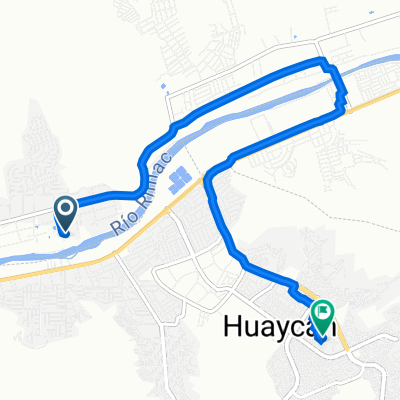
A cycling route starting in Santa María, Lima region, Peru.
Overview
About this route
- 36 min
- Duration
- 9.7 km
- Distance
- 88 m
- Ascent
- 90 m
- Descent
- 16.3 km/h
- Avg. speed
- 557 m
- Max. altitude
Route photos

Route quality
Waytypes & surfaces along the route
Waytypes
Road
7.7 km
(79 %)
Quiet road
2 km
(21 %)
Surfaces
Paved
6.5 km
(67 %)
Unpaved
0.1 km
(1 %)
Asphalt
6.5 km
(67 %)
Unpaved (undefined)
0.1 km
(1 %)
Undefined
3.1 km
(32 %)
Continue with Bikemap
Use, edit, or download this cycling route
You would like to ride -11.985, -76.839 a -11.985, -76.839 or customize it for your own trip? Here is what you can do with this Bikemap route:
Free features
- Save this route as favorite or in collections
- Copy & plan your own version of this route
- Sync your route with Garmin or Wahoo
Premium features
Free trial for 3 days, or one-time payment. More about Bikemap Premium.
- Navigate this route on iOS & Android
- Export a GPX / KML file of this route
- Create your custom printout (try it for free)
- Download this route for offline navigation
Discover more Premium features.
Get Bikemap PremiumFrom our community
Other popular routes starting in Santa María
 Dream (Hell) Climb
- Distance
- 117.8 km
- Ascent
- 4,751 m
- Descent
- 349 m
- Location
- Santa María, Lima region, Peru
 Calle Los Pinos, a Calle La Cantuta,
- Distance
- 9.7 km
- Ascent
- 158 m
- Descent
- 46 m
- Location
- Santa María, Lima region, Peru
- -11.985, -76.839 a -11.985, -76.839
- Distance
- 9.7 km
- Ascent
- 88 m
- Descent
- 90 m
- Location
- Santa María, Lima region, Peru
 Calle Los Pinos, a Calle La Cantuta,
- Distance
- 9.6 km
- Ascent
- 176 m
- Descent
- 63 m
- Location
- Santa María, Lima region, Peru
 De Avenida Esperanza 619, Lima a Vulcano 364, Lima
- Distance
- 7.9 km
- Ascent
- 12 m
- Descent
- 154 m
- Location
- Santa María, Lima region, Peru
 La Planicie - Parte 2
- Distance
- 28.5 km
- Ascent
- 238 m
- Descent
- 660 m
- Location
- Santa María, Lima region, Peru
 Ruta para Rumbo Agraria
- Distance
- 29.3 km
- Ascent
- 177 m
- Descent
- 262 m
- Location
- Santa María, Lima region, Peru
 De Santa Rosa, Ate a Calle Campanillas 137, Ate
- Distance
- 12.8 km
- Ascent
- 41 m
- Descent
- 232 m
- Location
- Santa María, Lima region, Peru
Open it in the app