

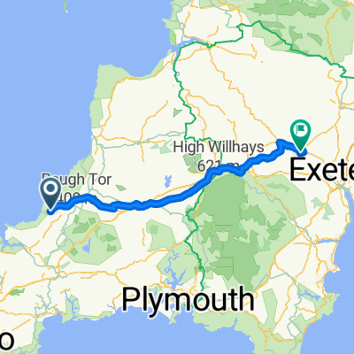
Camelford/Bodmin/lanhydrock
A cycling route starting in Camelford, England, United Kingdom.
Overview
About this route
- 2 h 20 min
- Duration
- 30.3 km
- Distance
- 355 m
- Ascent
- 437 m
- Descent
- 13 km/h
- Avg. speed
- 208 m
- Max. altitude

Route quality
Waytypes & surfaces along the route
Waytypes
Quiet road
13.9 km
(46 %)
Cycleway
13.3 km
(44 %)
Surfaces
Paved
4.2 km
(14 %)
Unpaved
11.8 km
(39 %)
Gravel
11.8 km
(39 %)
Asphalt
4.2 km
(14 %)
Undefined
14.2 km
(47 %)
Route highlights
Points of interest along the route
Accommodation after 1.6 km
Camelford caravan site
Continue with Bikemap
Use, edit, or download this cycling route
You would like to ride Camelford/Bodmin/lanhydrock or customize it for your own trip? Here is what you can do with this Bikemap route:
Free features
- Save this route as favorite or in collections
- Copy & plan your own version of this route
- Sync your route with Garmin or Wahoo
Premium features
Free trial for 3 days, or one-time payment. More about Bikemap Premium.
- Navigate this route on iOS & Android
- Export a GPX / KML file of this route
- Create your custom printout (try it for free)
- Download this route for offline navigation
Discover more Premium features.
Get Bikemap PremiumFrom our community
Other popular routes starting in Camelford
 10 Valley Truckle, Camelford to 1 Polmorla Road, Wadebridge
- Distance
- 16.2 km
- Ascent
- 70 m
- Descent
- 276 m
- Location
- Camelford, England, United Kingdom
 Camelford/Bodmin/lanhydrock
- Distance
- 30.3 km
- Ascent
- 355 m
- Descent
- 437 m
- Location
- Camelford, England, United Kingdom
 LE2JO DAY 3
- Distance
- 97.8 km
- Ascent
- 716 m
- Descent
- 870 m
- Location
- Camelford, England, United Kingdom
 LEJOG stage 2
- Distance
- 121.9 km
- Ascent
- 656 m
- Descent
- 786 m
- Location
- Camelford, England, United Kingdom
 14 Valley Truckle, Camelford to 8 Foundry Ct, Wadebridge
- Distance
- 16.6 km
- Ascent
- 284 m
- Descent
- 488 m
- Location
- Camelford, England, United Kingdom
 Boscastle to N Molton
- Distance
- 92.9 km
- Ascent
- 1,743 m
- Descent
- 1,805 m
- Location
- Camelford, England, United Kingdom
 Moderate route in Camelford
- Distance
- 28.5 km
- Ascent
- 634 m
- Descent
- 888 m
- Location
- Camelford, England, United Kingdom
 Wadebridge - Padstow
- Distance
- 44.9 km
- Ascent
- 216 m
- Descent
- 361 m
- Location
- Camelford, England, United Kingdom
Open it in the app