CTF-Sulzbach-2009-Hessen
A cycling route starting in Sulzbach am Main, Bavaria, Germany.
Overview
About this route
The 2009 route of the now 16th edition is impressive. Fast downhills, singletrails, long and/or steep climbs, a few technical sections, and excellent organization round off the picture. This year, catering reached its limits with over 500 participants. The insider tip is probably no longer a secret. Those who missed the date can follow the route with this data. No responsibility is taken for push sections.
- -:--
- Duration
- 31.6 km
- Distance
- 896 m
- Ascent
- 849 m
- Descent
- ---
- Avg. speed
- 363 m
- Max. altitude
Route quality
Waytypes & surfaces along the route
Waytypes
Track
21.2 km
(67 %)
Path
6.9 km
(22 %)
Surfaces
Paved
3.5 km
(11 %)
Unpaved
25.3 km
(80 %)
Ground
13.6 km
(43 %)
Gravel
8.5 km
(27 %)
Continue with Bikemap
Use, edit, or download this cycling route
You would like to ride CTF-Sulzbach-2009-Hessen or customize it for your own trip? Here is what you can do with this Bikemap route:
Free features
- Save this route as favorite or in collections
- Copy & plan your own version of this route
- Sync your route with Garmin or Wahoo
Premium features
Free trial for 3 days, or one-time payment. More about Bikemap Premium.
- Navigate this route on iOS & Android
- Export a GPX / KML file of this route
- Create your custom printout (try it for free)
- Download this route for offline navigation
Discover more Premium features.
Get Bikemap PremiumFrom our community
Other popular routes starting in Sulzbach am Main
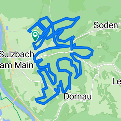
- Sulzbach-Eichelsbach-Geishöhe-Volkersbrunn
- Distance
- 49.7 km
- Ascent
- 957 m
- Descent
- 858 m
- Location
- Sulzbach am Main, Bavaria, Germany
- Sulzbach Pfaffenberg
- Distance
- 39.8 km
- Ascent
- 761 m
- Descent
- 761 m
- Location
- Sulzbach am Main, Bavaria, Germany
- 1. ausgeschilderte MTB Strecke Sulzbach
- Distance
- 28.7 km
- Ascent
- 573 m
- Descent
- 576 m
- Location
- Sulzbach am Main, Bavaria, Germany
- Sulzbach - Glattbach
- Distance
- 23.4 km
- Ascent
- 140 m
- Descent
- 74 m
- Location
- Sulzbach am Main, Bavaria, Germany
- Volkersbrunn-Mespelbrunn-Weibersbrunn-Eschau-Obernburg
- Distance
- 68.7 km
- Ascent
- 629 m
- Descent
- 629 m
- Location
- Sulzbach am Main, Bavaria, Germany
- Honischer Weizenrunde
- Distance
- 26.8 km
- Ascent
- 525 m
- Descent
- 525 m
- Location
- Sulzbach am Main, Bavaria, Germany
- Spessart-Hafenlohrtal-Engländer
- Distance
- 122.7 km
- Ascent
- 778 m
- Descent
- 778 m
- Location
- Sulzbach am Main, Bavaria, Germany
- 1. ausgeschilderte MTB Strecke Sulzbach
- Distance
- 28.7 km
- Ascent
- 542 m
- Descent
- 542 m
- Location
- Sulzbach am Main, Bavaria, Germany
Open it in the app