
Mittelschwerer Alpencross X10 via Brenta Dolomiti Aktualisiert am 15.09.2015
A cycling route starting in Scharnitz, Tyrol, Austria.
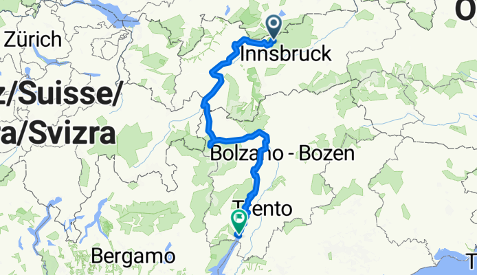
Overview
About this route
Alpenüberquerung durch die Zentralalpen mittlerer Schwierigkeit mit vielen landschaftlichen Highlights. Die Route und Streckenführung wurde von mir am 15.09.2015 aktualisiert. Im speziellen zwischen Venetalm und Pillerhöhe, Naturnseralm bis St. Walburg, Abfahrt vom Rabbijoch sowie Aufgrund von Baustellen und Umleitungen betroffene Teilstücke. Du willst alles, was zu einem tollen Alpencross-Erlebnis dazu gehört: gigantische Landschaften, traumhafte Trails, Anstrengung und das Glück am Abend, wenn Du es wieder geschafft hast? Und Du willst keinen leichten Alpencross, sondern einen ganz normal sportlichen mit mittlerer Schwierigkeit. Dann fahr mit gleichgesinnten Bikern in entspannter Atmosphäre die Traumroute von Leutasch nach Riva del Garda. Entdecke die spektakuläre Uinaschlucht, erklimme unter Anstrengung den Passo di Schlinig, erlebe die fantastische Aussicht am Rabbijoch, das umwerfende Panorama der Dolomiti di Brenta und den Fantastischen Flow der Alpentrails.
- 30 h 6 min
- Duration
- 439.4 km
- Distance
- 11,607 m
- Ascent
- 12,532 m
- Descent
- 14.6 km/h
- Avg. speed
- 1,603 m
- Avg. speed
Route quality
Waytypes & surfaces along the route
Waytypes
Track
126.1 km
(29 %)
Quiet road
100.2 km
(23 %)
Surfaces
Paved
273.8 km
(62 %)
Unpaved
96.8 km
(22 %)
Asphalt
263.1 km
(60 %)
Gravel
74.9 km
(17 %)
Continue with Bikemap
Use, edit, or download this cycling route
You would like to ride Mittelschwerer Alpencross X10 via Brenta Dolomiti Aktualisiert am 15.09.2015 or customize it for your own trip? Here is what you can do with this Bikemap route:
Free features
- Save this route as favorite or in collections
- Copy & plan your own version of this route
- Split it into stages to create a multi-day tour
- Sync your route with Garmin or Wahoo
Premium features
Free trial for 3 days, or one-time payment. More about Bikemap Premium.
- Navigate this route on iOS & Android
- Export a GPX / KML file of this route
- Create your custom printout (try it for free)
- Download this route for offline navigation
Discover more Premium features.
Get Bikemap PremiumFrom our community
Other popular routes starting in Scharnitz
 Karwendeltour 2009
- Distance
- 86.5 km
- Ascent
- 1,447 m
- Descent
- 1,843 m
- Location
- Scharnitz, Tyrol, Austria
 Mittelschwerer Alpencross X10 via Brenta Dolomiti Aktualisiert am 15.09.2015
- Distance
- 439.4 km
- Ascent
- 11,607 m
- Descent
- 12,532 m
- Location
- Scharnitz, Tyrol, Austria
 Gießenbach - Pfeishütte
- Distance
- 21.9 km
- Ascent
- 1,338 m
- Descent
- 446 m
- Location
- Scharnitz, Tyrol, Austria
 Karwendeltal bis Karwendelhaus
- Distance
- 35.5 km
- Ascent
- 822 m
- Descent
- 822 m
- Location
- Scharnitz, Tyrol, Austria
 MiWA>Verona
- Distance
- 486.2 km
- Ascent
- 2,568 m
- Descent
- 3,507 m
- Location
- Scharnitz, Tyrol, Austria
 Hinterriss - Falkenhütte
- Distance
- 31.7 km
- Ascent
- 971 m
- Descent
- 975 m
- Location
- Scharnitz, Tyrol, Austria
 Möslalm
- Distance
- 24.7 km
- Ascent
- 447 m
- Descent
- 447 m
- Location
- Scharnitz, Tyrol, Austria
 Pfeishütte
- Distance
- 20.8 km
- Ascent
- 1,350 m
- Descent
- 448 m
- Location
- Scharnitz, Tyrol, Austria
Open it in the app