- 72.1 km
- 185 m
- 185 m
- Brockville, Ontario, Canada
Waterfront Trail: Lake Ontario–St. Lawrence (Canada)
Waterfront Trail: Brockville to Prescott
A cycling route starting in Brockville, Ontario, Canada.
Overview
About this route
Ride the Waterfront Trail along the St. Lawrence from Brockville to Prescott. A mostly flat 23 km spin on smooth pavement with river views, marinas, and park stops. Roll out from Brockville's waterfront and historic railway tunnel, then finish at Prescott by Fort Wellington. Expect a few busier road sections through town, but shoulders are decent and navigation is easy. Perfect for a half-day cruise, a coffee out-and-back, or a link in a longer Lake Ontario-St. Lawrence ride.
- -:--
- Duration
- 23.4 km
- Distance
- 118 m
- Ascent
- 116 m
- Descent
- ---
- Avg. speed
- 106 m
- Max. altitude
Part of
Waterfront Trail: Lake Ontario–St. Lawrence (Canada)
33 routes
Route quality
Waytypes & surfaces along the route
Waytypes
Quiet road
6.1 km
(26 %)
Access road
0.5 km
(2 %)
Surfaces
Paved
22 km
(94 %)
Asphalt
20.9 km
(89 %)
Paved (undefined)
1.2 km
(5 %)
Undefined
1.4 km
(6 %)
Continue with Bikemap
Use, edit, or download this cycling route
You would like to ride Waterfront Trail: Brockville to Prescott or customize it for your own trip? Here is what you can do with this Bikemap route:
Free features
- Save this route as favorite or in collections
- Copy & plan your own version of this route
- Export a GPX file of this official route
- Export a KML file of this official route
- Sync your route with Garmin or Wahoo
Premium features
Free trial for 3 days, or one-time payment. More about Bikemap Premium.
- Navigate this route on iOS & Android
- Create your custom printout (try it for free)
- Download this route for offline navigation
Discover more Premium features.
Get Bikemap PremiumFrom our community
Other popular routes starting in Brockville
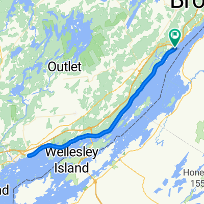
- Thousand Islands Parkway
- base camp
- 0.8 km
- 38 m
- 35 m
- Brockville, Ontario, Canada
- 306–344 Centennial Rd, Brockville to 306–344 Centennial Rd, Brockville
- 15.1 km
- 51 m
- 52 m
- Brockville, Ontario, Canada
- Brockville-Kingston 135km
- 134.7 km
- 209 m
- 245 m
- Brockville, Ontario, Canada
- Mallorytown: River and Ridges 2 (50km)
- 49.4 km
- 180 m
- 181 m
- Brockville, Ontario, Canada
- Brockville-Kingston 100km
- 98.1 km
- 226 m
- 259 m
- Brockville, Ontario, Canada
- Itinéraire vers Park St, Brockville
- 22.8 km
- 139 m
- 139 m
- Brockville, Ontario, Canada
- with g
- 12 km
- 79 m
- 49 m
- Brockville, Ontario, Canada
Open it in the app


