Sonnentour: Gleisdorf to Sankt Ruprecht an der Raab
A cycling route starting in Gleisdorf, Styria, Austria.
Overview
About this route
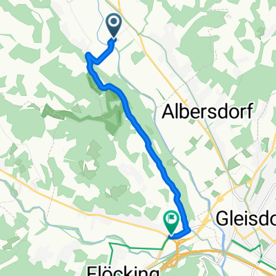
A short 5.6 km spin from Gleisdorf to Sankt Ruprecht an der Raab. Expect gentle rolling terrain with about 110 m of climbing on mostly quiet roads. Glide through the Raab valley countryside, then roll into one of Styria’s oldest market towns—perfect for a coffee by the river before heading back or onward.
- -:--
- Duration
- 5.6 km
- Distance
- 112 m
- Ascent
- 126 m
- Descent
- ---
- Avg. speed
- 454 m
- Max. altitude
Route quality
Waytypes & surfaces along the route
Waytypes
Quiet road
5.2 km
(93 %)
Road
0.4 km
(7 %)
Surfaces
Paved
2.5 km
(44 %)
Asphalt
2.5 km
(44 %)
Undefined
3.1 km
(56 %)
Continue with Bikemap
Use, edit, or download this cycling route
You would like to ride Sonnentour: Gleisdorf to Sankt Ruprecht an der Raab or customize it for your own trip? Here is what you can do with this Bikemap route:
Free features
- Save this route as favorite or in collections
- Copy & plan your own version of this route
- Sync your route with Garmin or Wahoo
Premium features
Free trial for 3 days, or one-time payment. More about Bikemap Premium.
- Navigate this route on iOS & Android
- Export a GPX / KML file of this route
- Create your custom printout (try it for free)
- Download this route for offline navigation
Discover more Premium features.
Get Bikemap PremiumFrom our community
Other popular routes starting in Gleisdorf
- Fredel's Strecke
- Distance
- 28.8 km
- Ascent
- 289 m
- Descent
- 286 m
- Location
- Gleisdorf, Styria, Austria
- Gleisdorf - Jennersdorf
- Distance
- 47.5 km
- Ascent
- 50 m
- Descent
- 127 m
- Location
- Gleisdorf, Styria, Austria
- Käferbohnen-Tour
- Distance
- 67 km
- Ascent
- 1,151 m
- Descent
- 1,151 m
- Location
- Gleisdorf, Styria, Austria
- Urscha-Sommeralm-Stubenbergsee-Urscha
- Distance
- 118.2 km
- Ascent
- 1,382 m
- Descent
- 1,381 m
- Location
- Gleisdorf, Styria, Austria
- Sonnentour: Gleisdorf to Sankt Ruprecht an der Raab
- Distance
- 5.6 km
- Ascent
- 112 m
- Descent
- 126 m
- Location
- Gleisdorf, Styria, Austria
- Radrunde durch Ludersdorfl-Waltersdorf
- Distance
- 15.6 km
- Ascent
- 284 m
- Descent
- 285 m
- Location
- Gleisdorf, Styria, Austria
- Urscha-Kumberg-Urscha
- Distance
- 42.5 km
- Ascent
- 338 m
- Descent
- 338 m
- Location
- Gleisdorf, Styria, Austria
- Kleine Urscha Runde
- Distance
- 10.8 km
- Ascent
- 286 m
- Descent
- 286 m
- Location
- Gleisdorf, Styria, Austria
Open it in the app