

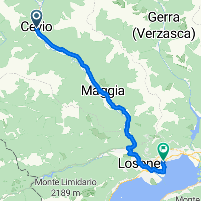
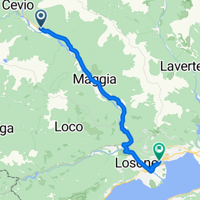
Percorso Valle Maggia - Tappa 2
A cycling route starting in Cevio, Canton Ticino, Switzerland.
Overview
About this route
Easy valley run from Cevio down the Maggia to Locarno. Mostly paved with some short gravel bits, plenty of signed cycleways and quiet roads. It trends downhill, so you get river views and villages on the way without much climbing. Roll into Locarno by Lake Maggiore—perfect for a swim or gelato on the Piazza Grande. Great option if you want a smooth 30 km ride with scenery and a relaxed finish.
- -:--
- Duration
- 30.5 km
- Distance
- 185 m
- Ascent
- 402 m
- Descent
- ---
- Avg. speed
- 424 m
- Max. altitude
Route quality
Waytypes & surfaces along the route
Waytypes
Quiet road
11.6 km
(38 %)
Cycleway
10.7 km
(35 %)
Surfaces
Paved
27.4 km
(90 %)
Unpaved
2.4 km
(8 %)
Asphalt
27.4 km
(90 %)
Gravel
2.4 km
(8 %)
Undefined
0.6 km
(2 %)
Continue with Bikemap
Use, edit, or download this cycling route
You would like to ride Percorso Valle Maggia - Tappa 2 or customize it for your own trip? Here is what you can do with this Bikemap route:
Free features
- Save this route as favorite or in collections
- Copy & plan your own version of this route
- Sync your route with Garmin or Wahoo
Premium features
Free trial for 3 days, or one-time payment. More about Bikemap Premium.
- Navigate this route on iOS & Android
- Export a GPX / KML file of this route
- Create your custom printout (try it for free)
- Download this route for offline navigation
Discover more Premium features.
Get Bikemap PremiumFrom our community
Other popular routes starting in Cevio
 Valle Bavona und Valle Maggia
- Distance
- 57.1 km
- Ascent
- 113 m
- Descent
- 858 m
- Location
- Cevio, Canton Ticino, Switzerland
 Percorso Valle Maggia - Tappa 2
- Distance
- 30.5 km
- Ascent
- 185 m
- Descent
- 402 m
- Location
- Cevio, Canton Ticino, Switzerland
 someo fusio bellizone
- Distance
- 96.1 km
- Ascent
- 1,654 m
- Descent
- 1,796 m
- Location
- Cevio, Canton Ticino, Switzerland
 Lago di Naret
- Distance
- 67.1 km
- Ascent
- 1,941 m
- Descent
- 1,941 m
- Location
- Cevio, Canton Ticino, Switzerland
 Wanderung im Bavonatal (TI)
- Distance
- 11.7 km
- Ascent
- 112 m
- Descent
- 608 m
- Location
- Cevio, Canton Ticino, Switzerland
 locarnonach Via Marcacci
- Distance
- 25.1 km
- Ascent
- 147 m
- Descent
- 317 m
- Location
- Cevio, Canton Ticino, Switzerland
 Laghi del Naret (cronoscalata)
- Distance
- 32 km
- Ascent
- 1,925 m
- Descent
- 46 m
- Location
- Cevio, Canton Ticino, Switzerland
 Cevio - Verscio
- Distance
- 60.6 km
- Ascent
- 1,185 m
- Descent
- 1,246 m
- Location
- Cevio, Canton Ticino, Switzerland
Open it in the app