- 30.5 km
- 716 m
- 721 m
- Almuñécar, Andalusia, Spain
EuroVelo 8 – Ruta Mediterránea (España)
EuroVelo 8: Almuñécar → Jete
A cycling route starting in Almuñécar, Andalusia, Spain.
Overview
About this route
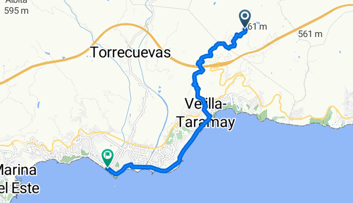
Short stretch of EuroVelo 8 from Almuñécar on the Costa Tropical to Jete, entering the Río Verde valley. About 9 km with mixed surface (road, bike lane and tracks) and a broken profile: approx. +190 m ascent and -530 m descent. Views of the sierra and subtropical crops (cherimoya, avocado). Watch out for traffic on the road sections and on the descents.
- -:--
- Duration
- 9 km
- Distance
- 192 m
- Ascent
- 527 m
- Descent
- ---
- Avg. speed
- 341 m
- Max. altitude
Part of
EuroVelo 8 – Ruta Mediterránea (España)
66 routes
Route quality
Waytypes & surfaces along the route
Waytypes
Road
3 km
(34 %)
Track
2.5 km
(28 %)
Surfaces
Paved
5.7 km
(64 %)
Unpaved
1.1 km
(12 %)
Asphalt
3.9 km
(43 %)
Concrete
1.4 km
(16 %)
Continue with Bikemap
Use, edit, or download this cycling route
You would like to ride EuroVelo 8: Almuñécar → Jete or customize it for your own trip? Here is what you can do with this Bikemap route:
Free features
- Save this route as favorite or in collections
- Copy & plan your own version of this route
- Export a GPX file of this official route
- Export a KML file of this official route
- Sync your route with Garmin or Wahoo
Premium features
Free trial for 3 days, or one-time payment. More about Bikemap Premium.
- Navigate this route on iOS & Android
- Create your custom printout (try it for free)
- Download this route for offline navigation
Discover more Premium features.
Get Bikemap PremiumFrom our community
Other popular routes starting in Almuñécar
- Las 7 cuestas: Almuñecar
- Almuñécar - Salobreña
- 15.8 km
- 908 m
- 911 m
- Almuñécar, Andalusia, Spain
- EuroVelo 8: Almuñécar → Jete
- 9 km
- 192 m
- 527 m
- Almuñécar, Andalusia, Spain
- Paseo de Cotobro, 9, Almuñécar nach Calle del Barranco de Cotobro, 2, Almuñécar
- 7.7 km
- 128 m
- 119 m
- Almuñécar, Andalusia, Spain
- Aluñécar Subida a la Cabra
- 33.3 km
- 1,463 m
- 215 m
- Almuñécar, Andalusia, Spain
- VCTS2021_dag6_ekstra
- 120.5 km
- 2,674 m
- 2,681 m
- Almuñécar, Andalusia, Spain
- VCTS2021_dag6_Goat-path
- 170.9 km
- 3,282 m
- 3,278 m
- Almuñécar, Andalusia, Spain
- Velilla - Peña Escrita
- 23.5 km
- 574 m
- 585 m
- Almuñécar, Andalusia, Spain
Open it in the app


