

sendas picassent - cova - clot
A cycling route starting in Picassent, Valencia, Spain.
Overview
About this route
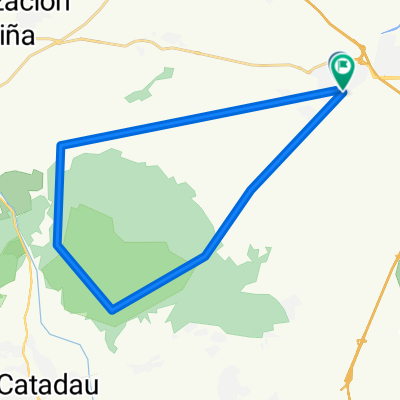
We will have coffee at Café Caramelo, first go to the path of the cova del águila, then do the hidden paths of the mirador and the short one along the barranco to descend the botifarra trail and have lunch at Jaco's in Alfarp. The return will be via the Aledua path and the Clot de les Tortugues.
- -:--
- Duration
- 50.1 km
- Distance
- 551 m
- Ascent
- 551 m
- Descent
- ---
- Avg. speed
- ---
- Max. altitude
Continue with Bikemap
Use, edit, or download this cycling route
You would like to ride sendas picassent - cova - clot or customize it for your own trip? Here is what you can do with this Bikemap route:
Free features
- Save this route as favorite or in collections
- Copy & plan your own version of this route
- Sync your route with Garmin or Wahoo
Premium features
Free trial for 3 days, or one-time payment. More about Bikemap Premium.
- Navigate this route on iOS & Android
- Export a GPX / KML file of this route
- Create your custom printout (try it for free)
- Download this route for offline navigation
Discover more Premium features.
Get Bikemap PremiumFrom our community
Other popular routes starting in Picassent
 Picassent-Toris-Iatova-La_Portera
- Distance
- 64.4 km
- Ascent
- 951 m
- Descent
- 380 m
- Location
- Picassent, Valencia, Spain
 5subiditas
- Distance
- 25.1 km
- Ascent
- 484 m
- Descent
- 484 m
- Location
- Picassent, Valencia, Spain
 Montes de Picassent
- Distance
- 32.3 km
- Ascent
- 347 m
- Descent
- 347 m
- Location
- Picassent, Valencia, Spain
 de picassent a la playa de pinedo
- Distance
- 18.9 km
- Ascent
- 16 m
- Descent
- 62 m
- Location
- Picassent, Valencia, Spain
 TOUS POR EL CANAL
- Distance
- 45.7 km
- Ascent
- 320 m
- Descent
- 285 m
- Location
- Picassent, Valencia, Spain
 sendas picassent - cova - clot
- Distance
- 50.1 km
- Ascent
- 551 m
- Descent
- 551 m
- Location
- Picassent, Valencia, Spain
 picassent-almussafes-benifaio-omet-picassent
- Distance
- 31.7 km
- Ascent
- 105 m
- Descent
- 90 m
- Location
- Picassent, Valencia, Spain
 Ruta 02-01-2010
- Distance
- 85.5 km
- Ascent
- 97 m
- Descent
- 97 m
- Location
- Picassent, Valencia, Spain
Open it in the app