

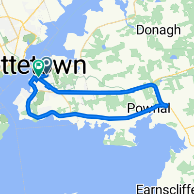
Confederation Trail - Charlottetown to Murray Harbour
A cycling route starting in Charlottetown, Prince Edward Island, Canada.
Overview
About this route
- -:--
- Duration
- 36.2 km
- Distance
- 147 m
- Ascent
- 194 m
- Descent
- ---
- Avg. speed
- 53 m
- Avg. speed
Route quality
Waytypes & surfaces along the route
Waytypes
Cycleway
31.1 km
(86 %)
Path
3.6 km
(10 %)
Surfaces
Paved
1.1 km
(3 %)
Unpaved
28.9 km
(80 %)
Gravel
25.2 km
(70 %)
Unpaved (undefined)
3.7 km
(10 %)
Continue with Bikemap
Use, edit, or download this cycling route
You would like to ride Confederation Trail - Charlottetown to Murray Harbour or customize it for your own trip? Here is what you can do with this Bikemap route:
Free features
- Save this route as favorite or in collections
- Copy & plan your own version of this route
- Sync your route with Garmin or Wahoo
Premium features
Free trial for 3 days, or one-time payment. More about Bikemap Premium.
- Navigate this route on iOS & Android
- Export a GPX / KML file of this route
- Create your custom printout (try it for free)
- Download this route for offline navigation
Discover more Premium features.
Get Bikemap PremiumFrom our community
Other popular routes starting in Charlottetown
 Confederation Trail - Charlottetown to Murray Harbour
- Distance
- 36.2 km
- Ascent
- 147 m
- Descent
- 194 m
- Location
- Charlottetown, Prince Edward Island, Canada
 2013 PEI Group Cycling Trip
- Distance
- 431 km
- Ascent
- 399 m
- Descent
- 399 m
- Location
- Charlottetown, Prince Edward Island, Canada
 Jour 7 IDLM Charlottetown à Campbells Cove Campground
- Distance
- 113.3 km
- Ascent
- 200 m
- Descent
- 196 m
- Location
- Charlottetown, Prince Edward Island, Canada
 Mount Mellick Loop Via Pownal-TCH
- Distance
- 30.5 km
- Ascent
- 241 m
- Descent
- 251 m
- Location
- Charlottetown, Prince Edward Island, Canada
 Mount Stewart
- Distance
- 31.6 km
- Ascent
- 85 m
- Descent
- 108 m
- Location
- Charlottetown, Prince Edward Island, Canada
 Brackley Point
- Distance
- 36.4 km
- Ascent
- 124 m
- Descent
- 143 m
- Location
- Charlottetown, Prince Edward Island, Canada
 550 University Ave, Charlottetown to 486 University Ave, Charlottetown
- Distance
- 17 km
- Ascent
- 133 m
- Descent
- 134 m
- Location
- Charlottetown, Prince Edward Island, Canada
 400 Mount Edward Rd, Charlottetown to 6 MacDonald Rd, Stratford
- Distance
- 8.1 km
- Ascent
- 29 m
- Descent
- 47 m
- Location
- Charlottetown, Prince Edward Island, Canada
Open it in the app