USBR 76: Charlottesville to Lake Monticello
A cycling route starting in Charlottesville, Virginia, United States.
Overview
About this route
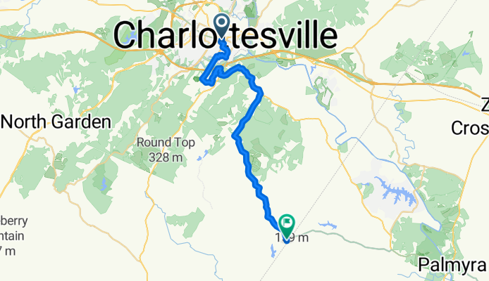
Roll out from Charlottesville, home of UVA and good coffee stops, and head southeast toward Lake Monticello. It’s about 29 km with steady rollers and around 400 m of climbing—enough to wake up the legs without wrecking them. Expect a road ride with a few busier stretches, so ride single file and bring lights. Finish by the lakeside neighborhoods for a mellow cool-down spin or a dip if you’ve got access. Great weekday training loop or weekend warm-up.
- -:--
- Duration
- 28.8 km
- Distance
- 415 m
- Ascent
- 387 m
- Descent
- ---
- Avg. speed
- 228 m
- Max. altitude
Route quality
Waytypes & surfaces along the route
Waytypes
Road
16.1 km
(56 %)
Quiet road
2.6 km
(9 %)
Surfaces
Paved
4.3 km
(15 %)
Asphalt
4.3 km
(15 %)
Undefined
24.4 km
(85 %)
Continue with Bikemap
Use, edit, or download this cycling route
You would like to ride USBR 76: Charlottesville to Lake Monticello or customize it for your own trip? Here is what you can do with this Bikemap route:
Free features
- Save this route as favorite or in collections
- Copy & plan your own version of this route
- Sync your route with Garmin or Wahoo
Premium features
Free trial for 3 days, or one-time payment. More about Bikemap Premium.
- Navigate this route on iOS & Android
- Export a GPX / KML file of this route
- Create your custom printout (try it for free)
- Download this route for offline navigation
Discover more Premium features.
Get Bikemap PremiumFrom our community
Other popular routes starting in Charlottesville
De Harvest Drive 164, Charlottesville a Harvest Drive 139, Charlottesville- Distance
- 8.8 km
- Ascent
- 96 m
- Descent
- 97 m
- Location
- Charlottesville, Virginia, United States
Route in Charlottesville- Distance
- 29.5 km
- Ascent
- 729 m
- Descent
- 732 m
- Location
- Charlottesville, Virginia, United States
Crozet / Dick Woods / Garth Road Loop- Distance
- 63 km
- Ascent
- 357 m
- Descent
- 383 m
- Location
- Charlottesville, Virginia, United States
Monticello out and back- Distance
- 10.3 km
- Ascent
- 245 m
- Descent
- 203 m
- Location
- Charlottesville, Virginia, United States
1356 River Rd, Charlottesville to 1356 River Rd, Charlottesville- Distance
- 6.7 km
- Ascent
- 26 m
- Descent
- 28 m
- Location
- Charlottesville, Virginia, United States
Dry Bridge-Tillman loop- Distance
- 49.5 km
- Ascent
- 440 m
- Descent
- 440 m
- Location
- Charlottesville, Virginia, United States
Route in Charlottesville- Distance
- 44.4 km
- Ascent
- 614 m
- Descent
- 615 m
- Location
- Charlottesville, Virginia, United States
USBR 76: Charlottesville to Lake Monticello- Distance
- 28.8 km
- Ascent
- 415 m
- Descent
- 387 m
- Location
- Charlottesville, Virginia, United States
Open it in the app

