
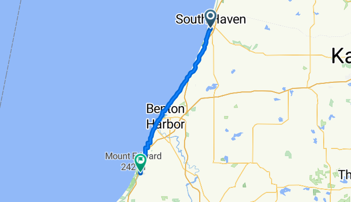
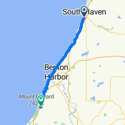
Route 35, Michigan: South Haven to Bridgman
A cycling route starting in South Haven, Michigan, United States.
Overview
About this route
Ride the Lake Michigan shoreline from South Haven’s beaches and lighthouse to Bridgman, gateway to Warren Dunes. It’s about 57 km with roughly 280 m of climbing, mostly on paved roads, with some busy sections—lights and a rear flasher help. Expect small towns, farm country, and lake views along the way. Stock up in South Haven before rolling out, then cap it off in Bridgman with a dune-side stroll.
- -:--
- Duration
- 57.3 km
- Distance
- 281 m
- Ascent
- 276 m
- Descent
- ---
- Avg. speed
- 217 m
- Max. altitude
Route quality
Waytypes & surfaces along the route
Waytypes
Quiet road
15.5 km
(27 %)
Road
1.7 km
(3 %)
Surfaces
Paved
37.2 km
(65 %)
Asphalt
21.2 km
(37 %)
Paved (undefined)
16 km
(28 %)
Undefined
20 km
(35 %)
Continue with Bikemap
Use, edit, or download this cycling route
You would like to ride Route 35, Michigan: South Haven to Bridgman or customize it for your own trip? Here is what you can do with this Bikemap route:
Free features
- Save this route as favorite or in collections
- Copy & plan your own version of this route
- Sync your route with Garmin or Wahoo
Premium features
Free trial for 3 days, or one-time payment. More about Bikemap Premium.
- Navigate this route on iOS & Android
- Export a GPX / KML file of this route
- Create your custom printout (try it for free)
- Download this route for offline navigation
Discover more Premium features.
Get Bikemap PremiumFrom our community
Other popular routes starting in South Haven
 Route 35, Michigan: South Haven to Bridgman
- Distance
- 57.3 km
- Ascent
- 281 m
- Descent
- 276 m
- Location
- South Haven, Michigan, United States
 351 Cherry St, South Haven to 351 Cherry St, South Haven
- Distance
- 18.8 km
- Ascent
- 85 m
- Descent
- 87 m
- Location
- South Haven, Michigan, United States
 South Haven to 2855 29th St SE, Kentwood
- Distance
- 111.3 km
- Ascent
- 479 m
- Descent
- 430 m
- Location
- South Haven, Michigan, United States
 State Park
- Distance
- 17.6 km
- Ascent
- 381 m
- Descent
- 379 m
- Location
- South Haven, Michigan, United States
 Monroe Blvd, South Haven to Kal-Haven Trail, Kalamazoo
- Distance
- 58.1 km
- Ascent
- 285 m
- Descent
- 185 m
- Location
- South Haven, Michigan, United States
 11533 76th St, South Haven to 11533 76th St, South Haven
- Distance
- 16.4 km
- Ascent
- 59 m
- Descent
- 59 m
- Location
- South Haven, Michigan, United States
 Kal Haven Trail, South Haven to 200 E Michigan Ave, Galesburg
- Distance
- 78.4 km
- Ascent
- 350 m
- Descent
- 295 m
- Location
- South Haven, Michigan, United States
 Day 2: South Haven > Pentwater
- Distance
- 203 km
- Ascent
- 231 m
- Descent
- 212 m
- Location
- South Haven, Michigan, United States
Open it in the app