De Ruelle Saint-Amand à Préfecture
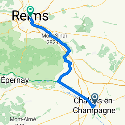
A cycling route starting in Châlons-en-Champagne, Grand Est, France.
Overview
About this route
- 74 h 36 min
- Duration
- 1,243 km
- Distance
- 7,598 m
- Ascent
- 7,595 m
- Descent
- 16.7 km/h
- Avg. speed
- 399 m
- Max. altitude
Route quality
Waytypes & surfaces along the route
Waytypes
Cycleway
323.2 km
(26 %)
Path
236.2 km
(19 %)
Surfaces
Paved
882.5 km
(71 %)
Unpaved
49.7 km
(4 %)
Asphalt
795.5 km
(64 %)
Paved (undefined)
87 km
(7 %)
Continue with Bikemap
Use, edit, or download this cycling route
You would like to ride De Ruelle Saint-Amand à Préfecture or customize it for your own trip? Here is what you can do with this Bikemap route:
Free features
- Save this route as favorite or in collections
- Copy & plan your own version of this route
- Split it into stages to create a multi-day tour
- Sync your route with Garmin or Wahoo
Premium features
Free trial for 3 days, or one-time payment. More about Bikemap Premium.
- Navigate this route on iOS & Android
- Export a GPX / KML file of this route
- Create your custom printout (try it for free)
- Download this route for offline navigation
Discover more Premium features.
Get Bikemap PremiumFrom our community
Other popular routes starting in Châlons-en-Champagne
- De Ruelle Saint-Amand à Préfecture
- Distance
- 1,243 km
- Ascent
- 7,598 m
- Descent
- 7,595 m
- Location
- Châlons-en-Champagne, Grand Est, France
- VF_2011_05_Chalons_BarSurAube
- Distance
- 97.9 km
- Ascent
- 350 m
- Descent
- 262 m
- Location
- Châlons-en-Champagne, Grand Est, France
- 201606-5 Chalons en Campage
- Distance
- 102.8 km
- Ascent
- 307 m
- Descent
- 286 m
- Location
- Châlons-en-Champagne, Grand Est, France
- Footing habituel
- Distance
- 7.3 km
- Ascent
- 5 m
- Descent
- 5 m
- Location
- Châlons-en-Champagne, Grand Est, France
- La Boucle des vallées de la Somme et de la Soude
- Distance
- 112.5 km
- Ascent
- 335 m
- Descent
- 335 m
- Location
- Châlons-en-Champagne, Grand Est, France
- Footing très tranquille
- Distance
- 4.2 km
- Ascent
- 9 m
- Descent
- 10 m
- Location
- Châlons-en-Champagne, Grand Est, France
- Rondje Champagne
- Distance
- 209.6 km
- Ascent
- 1,477 m
- Descent
- 1,476 m
- Location
- Châlons-en-Champagne, Grand Est, France
- Da Avenue du 8 Mai 1945, Saint-Martin-sur-le-Pré a 10–12 Rue Brigadier Général Searby, Vraux
- Distance
- 12.8 km
- Ascent
- 13 m
- Descent
- 28 m
- Location
- Châlons-en-Champagne, Grand Est, France
Open it in the app