Weg zur Downhillstrecke von Welschensteinach aus
A cycling route starting in Schuttertal, Baden-Württemberg, Germany.
Overview
About this route
Hi das ist der Kürzeste Weg von mir zuhause aus zur Downhillstrecke ! Grüße Stefan
- -:--
- Duration
- 0.8 km
- Distance
- 157 m
- Ascent
- 0 m
- Descent
- ---
- Avg. speed
- ---
- Avg. speed
Route quality
Waytypes & surfaces along the route
Waytypes
Track
0.8 km
(100 %)
Surfaces
Paved
0.6 km
(80 %)
Unpaved
0.2 km
(20 %)
Paved (undefined)
0.6 km
(80 %)
Gravel
0.2 km
(20 %)
Continue with Bikemap
Use, edit, or download this cycling route
You would like to ride Weg zur Downhillstrecke von Welschensteinach aus or customize it for your own trip? Here is what you can do with this Bikemap route:
Free features
- Save this route as favorite or in collections
- Copy & plan your own version of this route
- Sync your route with Garmin or Wahoo
Premium features
Free trial for 3 days, or one-time payment. More about Bikemap Premium.
- Navigate this route on iOS & Android
- Export a GPX / KML file of this route
- Create your custom printout (try it for free)
- Download this route for offline navigation
Discover more Premium features.
Get Bikemap PremiumFrom our community
Other popular routes starting in Schuttertal
- Weg zur Downhillstrecke von Welschensteinach aus
- Distance
- 0.8 km
- Ascent
- 157 m
- Descent
- 0 m
- Location
- Schuttertal, Baden-Württemberg, Germany
- Schuttertal GA1
- Distance
- 26.9 km
- Ascent
- 518 m
- Descent
- 516 m
- Location
- Schuttertal, Baden-Württemberg, Germany
- Bildsteinstraße 2A, Freiamt nach Bildsteinstraße 2A, Freiamt
- Distance
- 38.5 km
- Ascent
- 1,033 m
- Descent
- 1,017 m
- Location
- Schuttertal, Baden-Württemberg, Germany
- Waldkirch
- Distance
- 26.8 km
- Ascent
- 472 m
- Descent
- 632 m
- Location
- Schuttertal, Baden-Württemberg, Germany
- Schwarzwald Quer Schuttertal-Schramberg
- Distance
- 62.5 km
- Ascent
- 2,348 m
- Descent
- 1,912 m
- Location
- Schuttertal, Baden-Württemberg, Germany
- Goethestraße 3, Schuttertal nach Am Schießrain 7, Schuttertal
- Distance
- 36.9 km
- Ascent
- 1,309 m
- Descent
- 1,321 m
- Location
- Schuttertal, Baden-Württemberg, Germany
- MTB St. Georgen Teil II
- Distance
- 69.1 km
- Ascent
- 1,171 m
- Descent
- 1,452 m
- Location
- Schuttertal, Baden-Württemberg, Germany
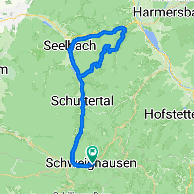
- Im Wolfersbach - Schweighausen - Steinach - Biberach - Seelbach
- Distance
- 43.1 km
- Ascent
- 826 m
- Descent
- 887 m
- Location
- Schuttertal, Baden-Württemberg, Germany
Open it in the app