

Cycle route
A cycling route starting in Luckington, England, United Kingdom.
Overview
About this route
Route created on plotaroute.com
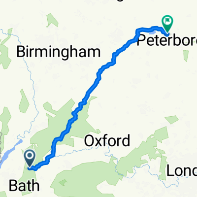
- 3 h 20 min
- Duration
- 78.5 km
- Distance
- 401 m
- Ascent
- 404 m
- Descent
- 23.6 km/h
- Avg. speed
- 136 m
- Max. altitude
Route quality
Waytypes & surfaces along the route
Waytypes
Road
44 km
(56 %)
Quiet road
22.8 km
(29 %)
Surfaces
Paved
12.6 km
(16 %)
Unpaved
6.3 km
(8 %)
Asphalt
12.6 km
(16 %)
Unpaved (undefined)
3.1 km
(4 %)
Continue with Bikemap
Use, edit, or download this cycling route
You would like to ride Cycle route or customize it for your own trip? Here is what you can do with this Bikemap route:
Free features
- Save this route as favorite or in collections
- Copy & plan your own version of this route
- Sync your route with Garmin or Wahoo
Premium features
Free trial for 3 days, or one-time payment. More about Bikemap Premium.
- Navigate this route on iOS & Android
- Export a GPX / KML file of this route
- Create your custom printout (try it for free)
- Download this route for offline navigation
Discover more Premium features.
Get Bikemap PremiumFrom our community
Other popular routes starting in Luckington
 Kerry ❤️
- Distance
- 41.3 km
- Ascent
- 180 m
- Descent
- 178 m
- Location
- Luckington, England, United Kingdom
 Cotswolds MTB
- Distance
- 54.3 km
- Ascent
- 758 m
- Descent
- 759 m
- Location
- Luckington, England, United Kingdom
 Badminton
- Distance
- 235.7 km
- Ascent
- 1,784 m
- Descent
- 1,854 m
- Location
- Luckington, England, United Kingdom
 Sherston Tetbury loop
- Distance
- 32.2 km
- Ascent
- 148 m
- Descent
- 146 m
- Location
- Luckington, England, United Kingdom
 Badminton to Burghley 2020 Route
- Distance
- 235.5 km
- Ascent
- 2,040 m
- Descent
- 2,110 m
- Location
- Luckington, England, United Kingdom
 Cycle route
- Distance
- 78.5 km
- Ascent
- 401 m
- Descent
- 404 m
- Location
- Luckington, England, United Kingdom
 Sherston Hullavington Stanton Grittleton
- Distance
- 34.9 km
- Ascent
- 131 m
- Descent
- 129 m
- Location
- Luckington, England, United Kingdom
 23GG0520 Cotswolds Gravel X (Final)
- Distance
- 91.7 km
- Ascent
- 1,012 m
- Descent
- 1,011 m
- Location
- Luckington, England, United Kingdom
Open it in the app