

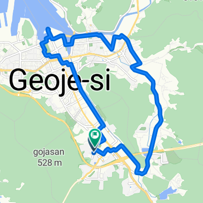
고현동, 거제시에서 고현동, 거제시까지
A cycling route starting in Sinhyeon, Gyeongsangnam-do, South Korea.
Overview
About this route
- 1 h 18 min
- Duration
- 17.9 km
- Distance
- 181 m
- Ascent
- 180 m
- Descent
- 13.7 km/h
- Avg. speed
- 55 m
- Max. altitude
Continue with Bikemap
Use, edit, or download this cycling route
You would like to ride 고현동, 거제시에서 고현동, 거제시까지 or customize it for your own trip? Here is what you can do with this Bikemap route:
Free features
- Save this route as favorite or in collections
- Copy & plan your own version of this route
- Sync your route with Garmin or Wahoo
Premium features
Free trial for 3 days, or one-time payment. More about Bikemap Premium.
- Navigate this route on iOS & Android
- Export a GPX / KML file of this route
- Create your custom printout (try it for free)
- Download this route for offline navigation
Discover more Premium features.
Get Bikemap PremiumFrom our community
Other popular routes starting in Sinhyeon
 상동동, 거제시에서 상동동, 거제시까지
- Distance
- 15.7 km
- Ascent
- 146 m
- Descent
- 137 m
- Location
- Sinhyeon, Gyeongsangnam-do, South Korea
 거제 북부
거제 북부- Distance
- 53.8 km
- Ascent
- 662 m
- Descent
- 662 m
- Location
- Sinhyeon, Gyeongsangnam-do, South Korea
 Okpo Zion the First to SHI
- Distance
- 12.6 km
- Ascent
- 270 m
- Descent
- 300 m
- Location
- Sinhyeon, Gyeongsangnam-do, South Korea
 Geojemyeon
- Distance
- 28.5 km
- Ascent
- 1,067 m
- Descent
- 1,061 m
- Location
- Sinhyeon, Gyeongsangnam-do, South Korea
 상동동, 거제시에서 수양로, 거제시까지
- Distance
- 4.7 km
- Ascent
- 3 m
- Descent
- 39 m
- Location
- Sinhyeon, Gyeongsangnam-do, South Korea
 okpo route
- Distance
- 15.1 km
- Ascent
- 419 m
- Descent
- 415 m
- Location
- Sinhyeon, Gyeongsangnam-do, South Korea
 Moutain Pass
- Distance
- 42.1 km
- Ascent
- 1,051 m
- Descent
- 902 m
- Location
- Sinhyeon, Gyeongsangnam-do, South Korea
 고현동, 거제시에서 고현동, 거제시까지
- Distance
- 17.9 km
- Ascent
- 181 m
- Descent
- 180 m
- Location
- Sinhyeon, Gyeongsangnam-do, South Korea
Open it in the app