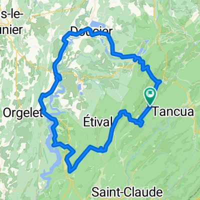
chaux dombief-franois-chaux crotenay- foncine le bas
A cycling route starting in Morbier, Bourgogne-Franche-Comté, France.
Overview
About this route
- 2 h 5 min
- Duration
- 33.1 km
- Distance
- 735 m
- Ascent
- 735 m
- Descent
- 15.9 km/h
- Avg. speed
- 903 m
- Max. altitude
Route quality
Waytypes & surfaces along the route
Waytypes
Track
9.6 km
(29 %)
Quiet road
8.3 km
(25 %)
Surfaces
Paved
26.5 km
(80 %)
Unpaved
2.6 km
(8 %)
Asphalt
26.2 km
(79 %)
Gravel
2.6 km
(8 %)
Continue with Bikemap
Use, edit, or download this cycling route
You would like to ride chaux dombief-franois-chaux crotenay- foncine le bas or customize it for your own trip? Here is what you can do with this Bikemap route:
Free features
- Save this route as favorite or in collections
- Copy & plan your own version of this route
- Sync your route with Garmin or Wahoo
Premium features
Free trial for 3 days, or one-time payment. More about Bikemap Premium.
- Navigate this route on iOS & Android
- Export a GPX / KML file of this route
- Create your custom printout (try it for free)
- Download this route for offline navigation
Discover more Premium features.
Get Bikemap PremiumFrom our community
Other popular routes starting in Morbier
- Lyon Wien 2. Etappe
- Distance
- 205.1 km
- Ascent
- 1,479 m
- Descent
- 1,996 m
- Location
- Morbier, Bourgogne-Franche-Comté, France
- chaux dombief-franois-chaux crotenay- foncine le bas
- Distance
- 33.1 km
- Ascent
- 735 m
- Descent
- 735 m
- Location
- Morbier, Bourgogne-Franche-Comté, France
- Grande Rue, Châtelblanc nach Rue de Salins, Pontarlier
- Distance
- 40.2 km
- Ascent
- 200 m
- Descent
- 385 m
- Location
- Morbier, Bourgogne-Franche-Comté, France
- kikitrip étape n°04
- Distance
- 41.5 km
- Ascent
- 347 m
- Descent
- 610 m
- Location
- Morbier, Bourgogne-Franche-Comté, France
- Boucle foncine
- Distance
- 20.4 km
- Ascent
- 281 m
- Descent
- 285 m
- Location
- Morbier, Bourgogne-Franche-Comté, France
- Tour des Lacs jurassiens
- Distance
- 108 km
- Ascent
- 1,207 m
- Descent
- 1,194 m
- Location
- Morbier, Bourgogne-Franche-Comté, France
- Jura étape 2
- Distance
- 50.1 km
- Ascent
- 623 m
- Descent
- 670 m
- Location
- Morbier, Bourgogne-Franche-Comté, France
- Foncine le bas - Louhans
- Distance
- 80.1 km
- Ascent
- 716 m
- Descent
- 1,332 m
- Location
- Morbier, Bourgogne-Franche-Comté, France
Open it in the app