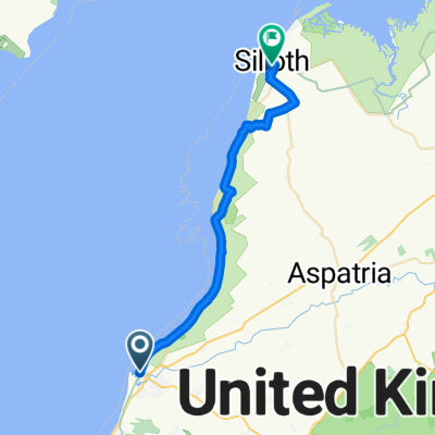
Day 2 long strict
A cycling route starting in Maryport, England, United Kingdom.
Overview
About this route
- 4 h 31 min
- Duration
- 77.4 km
- Distance
- 173 m
- Ascent
- 162 m
- Descent
- 17.1 km/h
- Avg. speed
- 41 m
- Avg. speed
Route quality
Waytypes & surfaces along the route
Waytypes
Road
36.1 km
(47 %)
Cycleway
12.5 km
(16 %)
Surfaces
Paved
16.8 km
(22 %)
Unpaved
0.1 km
(<1 %)
Asphalt
15.4 km
(20 %)
Concrete
1.4 km
(2 %)
Continue with Bikemap
Use, edit, or download this cycling route
You would like to ride Day 2 long strict or customize it for your own trip? Here is what you can do with this Bikemap route:
Free features
- Save this route as favorite or in collections
- Copy & plan your own version of this route
- Sync your route with Garmin or Wahoo
Premium features
Free trial for 3 days, or one-time payment. More about Bikemap Premium.
- Navigate this route on iOS & Android
- Export a GPX / KML file of this route
- Create your custom printout (try it for free)
- Download this route for offline navigation
Discover more Premium features.
Get Bikemap PremiumFrom our community
Other popular routes starting in Maryport
- John Street 59 to Lower Church Street 3
- Distance
- 49.9 km
- Ascent
- 244 m
- Descent
- 296 m
- Location
- Maryport, England, United Kingdom
- Hadrian's Wall
- Distance
- 196.1 km
- Ascent
- 554 m
- Descent
- 536 m
- Location
- Maryport, England, United Kingdom
- Maryport - Silloth
- Distance
- 44.1 km
- Ascent
- 17 m
- Descent
- 16 m
- Location
- Maryport, England, United Kingdom
- Cracking ride
- Distance
- 34.4 km
- Ascent
- 164 m
- Descent
- 168 m
- Location
- Maryport, England, United Kingdom
- 20 miles
- Distance
- 31.7 km
- Ascent
- 247 m
- Descent
- 299 m
- Location
- Maryport, England, United Kingdom
- Route from Marine Road, Maryport
- Distance
- 30.5 km
- Ascent
- 100 m
- Descent
- 57 m
- Location
- Maryport, England, United Kingdom
- Day 2 long strict
- Distance
- 77.4 km
- Ascent
- 173 m
- Descent
- 162 m
- Location
- Maryport, England, United Kingdom
- Day 2 strict
- Distance
- 63.6 km
- Ascent
- 154 m
- Descent
- 142 m
- Location
- Maryport, England, United Kingdom
Open it in the app