

Von Lutherstadt Wittenberg zum Schwielowsee
A cycling route starting in Wittenburg, Saxony-Anhalt, Germany.
Overview
About this route
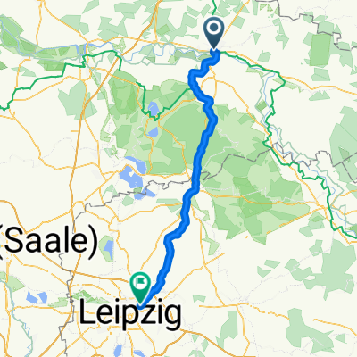
From Lutherstadt Wittenberg on the Elbe, the route begins with a steady climb towards Fläming. Near Groß Marzehns, you reach the highest point (160 m). Then there's a swift descent heading towards Neuendorf and Niemegk. The road continues gently downhill through the Planetal valley to Brück/Mark. From there, the route follows the R1 cycle path to Borkheide and on to Borkwalde. After that, you head towards Klaistow and then Glindow. The route rises steadily from Klaistow up to the highest point (80 m). Shortly after, you leave the main road, descending a quiet lane via Kammerode towards Schwielowsee. You pass through Petzow and Geltow before taking the cycle path along the north shore of the lake to the ferry in Caputh.
- 4 h 26 min
- Duration
- 78.6 km
- Distance
- 356 m
- Ascent
- 399 m
- Descent
- 17.7 km/h
- Avg. speed
- 160 m
- Max. altitude

Route quality
Waytypes & surfaces along the route
Waytypes
Path
22.8 km
(29 %)
Road
12.6 km
(16 %)
Surfaces
Paved
67.6 km
(86 %)
Unpaved
3.1 km
(4 %)
Asphalt
67.6 km
(86 %)
Gravel
3.1 km
(4 %)
Undefined
7.9 km
(10 %)
Continue with Bikemap
Use, edit, or download this cycling route
You would like to ride Von Lutherstadt Wittenberg zum Schwielowsee or customize it for your own trip? Here is what you can do with this Bikemap route:
Free features
- Save this route as favorite or in collections
- Copy & plan your own version of this route
- Sync your route with Garmin or Wahoo
Premium features
Free trial for 3 days, or one-time payment. More about Bikemap Premium.
- Navigate this route on iOS & Android
- Export a GPX / KML file of this route
- Create your custom printout (try it for free)
- Download this route for offline navigation
Discover more Premium features.
Get Bikemap PremiumFrom our community
Other popular routes starting in Wittenburg
 Wittenberg-Torgau_L
- Distance
- 69.9 km
- Ascent
- 441 m
- Descent
- 1,407 m
- Location
- Wittenburg, Saxony-Anhalt, Germany
 2009 - Lutherstadt Wittenberge - Gnoien (MV) - Waren/Müritz
- Distance
- 394.9 km
- Ascent
- 983 m
- Descent
- 1,005 m
- Location
- Wittenburg, Saxony-Anhalt, Germany
 Wörlitz Runde
- Distance
- 40.6 km
- Ascent
- 35 m
- Descent
- 36 m
- Location
- Wittenburg, Saxony-Anhalt, Germany
 Wittenberg-Leipzig 2007
- Distance
- 66.5 km
- Ascent
- 270 m
- Descent
- 218 m
- Location
- Wittenburg, Saxony-Anhalt, Germany
 6 - Wittenberg- Berlin 125 k
- Distance
- 133.2 km
- Ascent
- 849 m
- Descent
- 890 m
- Location
- Wittenburg, Saxony-Anhalt, Germany
 4. Etappe, Wittenberg-Leipzig
- Distance
- 75.7 km
- Ascent
- 208 m
- Descent
- 173 m
- Location
- Wittenburg, Saxony-Anhalt, Germany
 Elbe-3.2 Wittenberg-Dessau/Aken
- Distance
- 53.8 km
- Ascent
- 85 m
- Descent
- 104 m
- Location
- Wittenburg, Saxony-Anhalt, Germany
 005_Mitteldeutschlandtour2010_Tag05_Lutherstadt Wittenberg-Belgern
- Distance
- 87.7 km
- Ascent
- 96 m
- Descent
- 54 m
- Location
- Wittenburg, Saxony-Anhalt, Germany
Open it in the app