Rue Basse du Remparts, Saint-Florentin to Rue de la Fosse Dionne, Tonnerre
A cycling route starting in Saint-Florentin, Bourgogne-Franche-Comté, France.
Overview
About this route
- 1 h 35 min
- Duration
- 29 km
- Distance
- 74 m
- Ascent
- 52 m
- Descent
- 18.3 km/h
- Avg. speed
- 148 m
- Max. altitude
Route photos
Route quality
Waytypes & surfaces along the route
Waytypes
Path
17.8 km
(62 %)
Quiet road
7.9 km
(27 %)
Surfaces
Paved
19.8 km
(68 %)
Unpaved
0 km
(<1 %)
Asphalt
19.6 km
(68 %)
Concrete
0.2 km
(<1 %)
Continue with Bikemap
Use, edit, or download this cycling route
You would like to ride Rue Basse du Remparts, Saint-Florentin to Rue de la Fosse Dionne, Tonnerre or customize it for your own trip? Here is what you can do with this Bikemap route:
Free features
- Save this route as favorite or in collections
- Copy & plan your own version of this route
- Sync your route with Garmin or Wahoo
Premium features
Free trial for 3 days, or one-time payment. More about Bikemap Premium.
- Navigate this route on iOS & Android
- Export a GPX / KML file of this route
- Create your custom printout (try it for free)
- Download this route for offline navigation
Discover more Premium features.
Get Bikemap PremiumFrom our community
Other popular routes starting in Saint-Florentin
- Rue Basse du Remparts, Saint-Florentin to Rue de la Fosse Dionne, Tonnerre
- Distance
- 29 km
- Ascent
- 74 m
- Descent
- 52 m
- Location
- Saint-Florentin, Bourgogne-Franche-Comté, France
- Rue du Bassin, Saint-Florentin to Chemin d'Armeau, Villevallier
- Distance
- 42 km
- Ascent
- 189 m
- Descent
- 218 m
- Location
- Saint-Florentin, Bourgogne-Franche-Comté, France
- 04 St -Florentine - Montbard 82 Km 560 Hm
- Distance
- 81.8 km
- Ascent
- 309 m
- Descent
- 203 m
- Location
- Saint-Florentin, Bourgogne-Franche-Comté, France
- 18 Avenue du Général Leclerc, Saint-Florentin to 5 Rue des Trois Cailloux, Gurgy
- Distance
- 34.4 km
- Ascent
- 46 m
- Descent
- 79 m
- Location
- Saint-Florentin, Bourgogne-Franche-Comté, France
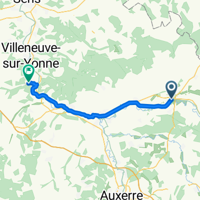
- Projet J1 - St Florentin/ Buffon
- Distance
- 69.8 km
- Ascent
- 221 m
- Descent
- 142 m
- Location
- Saint-Florentin, Bourgogne-Franche-Comté, France
- De Place de l'Église 15, Saint-Florentin à Route de Tonnerre 2, Vézinnes
- Distance
- 47.8 km
- Ascent
- 382 m
- Descent
- 370 m
- Location
- Saint-Florentin, Bourgogne-Franche-Comté, France
- Paris_04
- Distance
- 95.8 km
- Ascent
- 258 m
- Descent
- 351 m
- Location
- Saint-Florentin, Bourgogne-Franche-Comté, France
- 2020 Bourgogne dag 1
- Distance
- 108 km
- Ascent
- 87 m
- Descent
- 38 m
- Location
- Saint-Florentin, Bourgogne-Franche-Comté, France
Open it in the app