
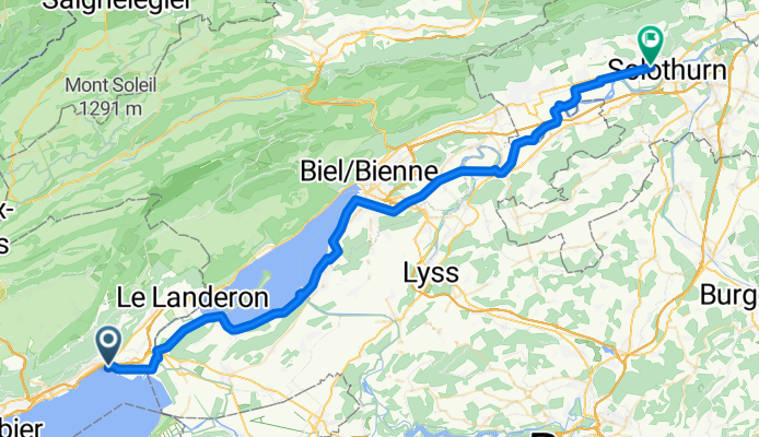
Solothurn Neuenburg, 4 Etappe Neuenburg
A cycling route starting in Saint-Blaise, Canton of Neuchâtel, Switzerland.
Overview
About this route
- 3 h 35 min
- Duration
- 57.6 km
- Distance
- 353 m
- Ascent
- 337 m
- Descent
- 16.1 km/h
- Avg. speed
- 469 m
- Max. altitude

Route quality
Waytypes & surfaces along the route
Waytypes
Quiet road
27.1 km
(47 %)
Track
15 km
(26 %)
Surfaces
Paved
35.7 km
(62 %)
Unpaved
15.6 km
(27 %)
Asphalt
33.4 km
(58 %)
Gravel
8.1 km
(14 %)
Continue with Bikemap
Use, edit, or download this cycling route
You would like to ride Solothurn Neuenburg, 4 Etappe Neuenburg or customize it for your own trip? Here is what you can do with this Bikemap route:
Free features
- Save this route as favorite or in collections
- Copy & plan your own version of this route
- Sync your route with Garmin or Wahoo
Premium features
Free trial for 3 days, or one-time payment. More about Bikemap Premium.
- Navigate this route on iOS & Android
- Export a GPX / KML file of this route
- Create your custom printout (try it for free)
- Download this route for offline navigation
Discover more Premium features.
Get Bikemap PremiumFrom our community
Other popular routes starting in Saint-Blaise
 De Chemin de Creuze 18, St-Blaise à Ruelle de l'Avoyer 6, St-Blaise
- Distance
- 24.2 km
- Ascent
- 584 m
- Descent
- 580 m
- Location
- Saint-Blaise, Canton of Neuchâtel, Switzerland
 Chaumont-Chsseral
- Distance
- 38.4 km
- Ascent
- 812 m
- Descent
- 1,295 m
- Location
- Saint-Blaise, Canton of Neuchâtel, Switzerland
 Rue du Tilleul, St-Blaise nach Weissensteinstrasse, Bern
- Distance
- 47.2 km
- Ascent
- 441 m
- Descent
- 367 m
- Location
- Saint-Blaise, Canton of Neuchâtel, Switzerland
 eVTT Crête du Chasseral
- Distance
- 67.9 km
- Ascent
- 2,308 m
- Descent
- 2,317 m
- Location
- Saint-Blaise, Canton of Neuchâtel, Switzerland
 Chasseral-Soleil-Vue des Alpes
- Distance
- 108.5 km
- Ascent
- 2,984 m
- Descent
- 2,886 m
- Location
- Saint-Blaise, Canton of Neuchâtel, Switzerland
 Neuchatel-Yverdon les Bains
- Distance
- 47.6 km
- Ascent
- 354 m
- Descent
- 352 m
- Location
- Saint-Blaise, Canton of Neuchâtel, Switzerland
 Interval Neuchatel
- Distance
- 7.6 km
- Ascent
- 27 m
- Descent
- 635 m
- Location
- Saint-Blaise, Canton of Neuchâtel, Switzerland
 Chaumont - Col Chasseral
- Distance
- 19.4 km
- Ascent
- 757 m
- Descent
- 235 m
- Location
- Saint-Blaise, Canton of Neuchâtel, Switzerland
Open it in the app