
Radeln_wo_einst_die_Dampflock_fuhr
A cycling route starting in Plankenfels, Bavaria, Germany.
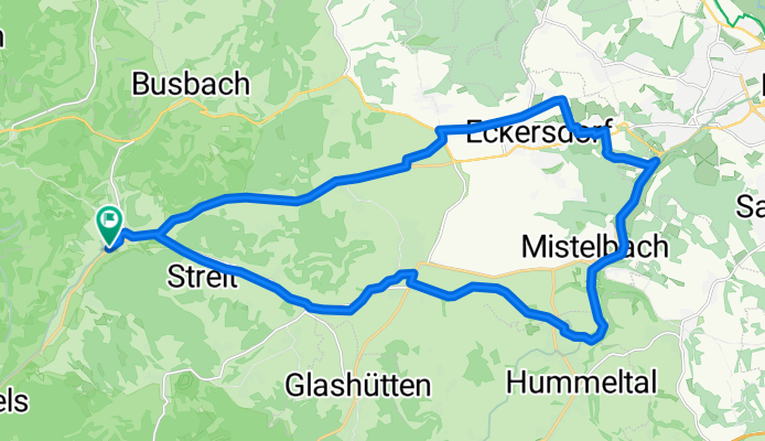
Overview
About this route
These GPS data are the property of the geo-coaching project and are intended solely for private use. Commercial use is not permitted without authorization.
- 1 h 51 min
- Duration
- 29 km
- Distance
- 202 m
- Ascent
- 205 m
- Descent
- 15.6 km/h
- Avg. speed
- 454 m
- Max. altitude

Continue with Bikemap
Use, edit, or download this cycling route
You would like to ride Radeln_wo_einst_die_Dampflock_fuhr or customize it for your own trip? Here is what you can do with this Bikemap route:
Free features
- Save this route as favorite or in collections
- Copy & plan your own version of this route
- Sync your route with Garmin or Wahoo
Premium features
Free trial for 3 days, or one-time payment. More about Bikemap Premium.
- Navigate this route on iOS & Android
- Export a GPX / KML file of this route
- Create your custom printout (try it for free)
- Download this route for offline navigation
Discover more Premium features.
Get Bikemap PremiumFrom our community
Other popular routes starting in Plankenfels
 Radeln_wo_einst_die_Dampflock_fuhr
- Distance
- 29 km
- Ascent
- 202 m
- Descent
- 205 m
- Location
- Plankenfels, Bavaria, Germany
 D_Bayern_Obernsees-StreiterBerg-NeubürgNaturKunstRaum-Wohnsgehaig-Mengersdorf-Truppach_RR-11,3km-250hm
- Distance
- 11.2 km
- Ascent
- 242 m
- Descent
- 239 m
- Location
- Plankenfels, Bavaria, Germany
 2016_03 MTB Lochautal - Plankenstein - Aufseßtal
- Distance
- 40 km
- Ascent
- 430 m
- Descent
- 430 m
- Location
- Plankenfels, Bavaria, Germany
 Brauereienweg
- Distance
- 41.8 km
- Ascent
- 338 m
- Descent
- 339 m
- Location
- Plankenfels, Bavaria, Germany
 Brauerrei-Tour II/2010
- Distance
- 45.2 km
- Ascent
- 670 m
- Descent
- 670 m
- Location
- Plankenfels, Bavaria, Germany
 05.05.2013
- Distance
- 76.6 km
- Ascent
- 755 m
- Descent
- 755 m
- Location
- Plankenfels, Bavaria, Germany
 Breitenlesau-Runde
- Distance
- 111.9 km
- Ascent
- 1,029 m
- Descent
- 1,028 m
- Location
- Plankenfels, Bavaria, Germany
 Brauereienweg
- Distance
- 41.8 km
- Ascent
- 383 m
- Descent
- 383 m
- Location
- Plankenfels, Bavaria, Germany
Open it in the app