

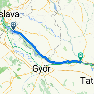
Day 2 - Šamorín - Komárno
A cycling route starting in Šamorín, Trnava Region, Slovakia.
Overview
About this route
- 4 h 16 min
- Duration
- 80.4 km
- Distance
- 75 m
- Ascent
- 88 m
- Descent
- 18.9 km/h
- Avg. speed
- 130 m
- Max. altitude

Route quality
Waytypes & surfaces along the route
Waytypes
Cycleway
76.3 km
(95 %)
Quiet road
1.7 km
(2 %)
Surfaces
Paved
76.1 km
(95 %)
Unpaved
4.1 km
(5 %)
Asphalt
74.3 km
(92 %)
Pebblestone
4.1 km
(5 %)
Continue with Bikemap
Use, edit, or download this cycling route
You would like to ride Day 2 - Šamorín - Komárno or customize it for your own trip? Here is what you can do with this Bikemap route:
Free features
- Save this route as favorite or in collections
- Copy & plan your own version of this route
- Split it into stages to create a multi-day tour
- Sync your route with Garmin or Wahoo
Premium features
Free trial for 3 days, or one-time payment. More about Bikemap Premium.
- Navigate this route on iOS & Android
- Export a GPX / KML file of this route
- Create your custom printout (try it for free)
- Download this route for offline navigation
Discover more Premium features.
Get Bikemap PremiumFrom our community
Other popular routes starting in Šamorín
 2014_Slovakia_Danube_Šamorin_Vojka nad Dunajom
- Distance
- 46.2 km
- Ascent
- 23 m
- Descent
- 21 m
- Location
- Šamorín, Trnava Region, Slovakia
 Route to Bratislava
- Distance
- 26.8 km
- Ascent
- 51 m
- Descent
- 37 m
- Location
- Šamorín, Trnava Region, Slovakia
 a Duna víztározó körül 2015.04.19.
- Distance
- 100 km
- Ascent
- 61 m
- Descent
- 61 m
- Location
- Šamorín, Trnava Region, Slovakia
 2014_Samorín_ Vojka nad Dunajom_Šamorín
- Distance
- 46.2 km
- Ascent
- 51 m
- Descent
- 49 m
- Location
- Šamorín, Trnava Region, Slovakia
 Day 2 - Šamorín - Komárno
- Distance
- 80.4 km
- Ascent
- 75 m
- Descent
- 88 m
- Location
- Šamorín, Trnava Region, Slovakia
 Burgenland
- Distance
- 225.1 km
- Ascent
- 268 m
- Descent
- 270 m
- Location
- Šamorín, Trnava Region, Slovakia
 Blatná na Ostrove do Blatná na Ostrove
- Distance
- 47.9 km
- Ascent
- 175 m
- Descent
- 172 m
- Location
- Šamorín, Trnava Region, Slovakia
 najvacsi chill-smrt
- Distance
- 58.9 km
- Ascent
- 45 m
- Descent
- 48 m
- Location
- Šamorín, Trnava Region, Slovakia
Open it in the app