

Overview
About this route
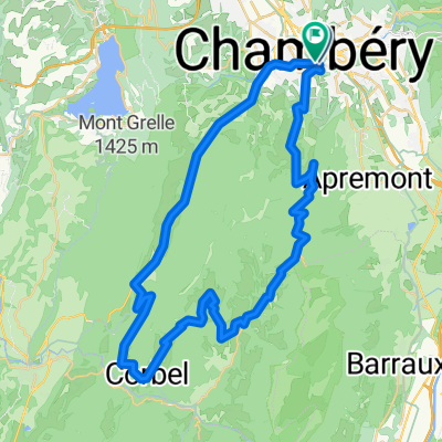
- 7 h 15 min
- Duration
- 107.1 km
- Distance
- 3,648 m
- Ascent
- 2,762 m
- Descent
- 14.8 km/h
- Avg. speed
- 1,161 m
- Max. altitude

Part of
Vercquie
7 stages
Route quality
Waytypes & surfaces along the route
Waytypes
Road
46.6 km
(44 %)
Cycleway
13.1 km
(12 %)
Surfaces
Paved
84.6 km
(79 %)
Unpaved
0.8 km
(<1 %)
Asphalt
84.2 km
(79 %)
Loose gravel
0.8 km
(<1 %)
Continue with Bikemap
Use, edit, or download this cycling route
You would like to ride ChamVildlCham 1/4bis or customize it for your own trip? Here is what you can do with this Bikemap route:
Free features
- Save this route as favorite or in collections
- Copy & plan your own version of this route
- Split it into stages to create a multi-day tour
- Sync your route with Garmin or Wahoo
Premium features
Free trial for 3 days, or one-time payment. More about Bikemap Premium.
- Navigate this route on iOS & Android
- Export a GPX / KML file of this route
- Create your custom printout (try it for free)
- Download this route for offline navigation
Discover more Premium features.
Get Bikemap PremiumFrom our community
Other popular routes starting in Chambéry
 AZAZ
AZAZ- Distance
- 7.3 km
- Ascent
- 101 m
- Descent
- 129 m
- Location
- Chambéry, Auvergne-Rhône-Alpes, France
 ChamVildlCham 1/4ter
- Distance
- 127.9 km
- Ascent
- 5,077 m
- Descent
- 4,190 m
- Location
- Chambéry, Auvergne-Rhône-Alpes, France
 ESSAIS XXXXX
- Distance
- 16.1 km
- Ascent
- 188 m
- Descent
- 125 m
- Location
- Chambéry, Auvergne-Rhône-Alpes, France
 ChamVildlCham 1/4bis
- Distance
- 107.1 km
- Ascent
- 3,648 m
- Descent
- 2,762 m
- Location
- Chambéry, Auvergne-Rhône-Alpes, France
 Circuit de Chartuese
- Distance
- 54 km
- Ascent
- 1,330 m
- Descent
- 1,330 m
- Location
- Chambéry, Auvergne-Rhône-Alpes, France
 Chartreuse Alps loop via Col du Granier
- Distance
- 58.9 km
- Ascent
- 1,708 m
- Descent
- 1,550 m
- Location
- Chambéry, Auvergne-Rhône-Alpes, France
 ChamVildlCham 1/4
- Distance
- 125.5 km
- Ascent
- 4,630 m
- Descent
- 3,744 m
- Location
- Chambéry, Auvergne-Rhône-Alpes, France
 A 01-04-CHAMBERY/GRENOBLE 64 KM
- Distance
- 62.7 km
- Ascent
- 130 m
- Descent
- 189 m
- Location
- Chambéry, Auvergne-Rhône-Alpes, France
Open it in the app