Tieringen-Weilen
- 38.7 km
- 353 m
- 352 m
- Hausen am Tann, Baden-Wurttemberg, Germany
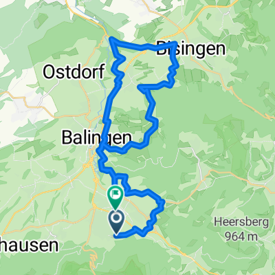
A cycling route starting in Hausen am Tann, Baden-Wurttemberg, Germany.
Overview
From the Balingen-Weilstetten sports field below Hörnle and Gräblesberg, gravel paths through the forest up to the sports field above Albstadt-Laufen. Up the lightly trafficked road K7145 until just before Meßstetten-Tieringen. Then gently rolling through open terrain, partly asphalt, partly grass turf to the Hörnle viewpoint. Over grass turf and gravel path to the Berghütte inn, possible first stop. Steep asphalt road downhill, passing the villages of Tieringen up to the Lochen Pass road. Follow this for about 300 meters and then continue gently downhill via the K7170 to Hausen am Tann. Within the village on asphalt, sometimes quite steep, past the Oberhauseb farmstead and further partly gravel to the Lochensteinbrünnle. From here, up a forest path to the saddle between Wenzelstein and the split rock with its beach chair idyll. Back to Lochenbrünnle and in the saddle between Lochenstein and split rock, detour the latter below on its north side to the saddle between Hoher Fels and Plettenberg, with a small hut on the left. Detour the latter below on the north side. On a scarcely trafficked road, partly steep uphill to Plettenberg with possible stop in the former sheepfold, the hut of the Swabian Alb association. Steeply downhill back to Dotternhausen, passing Cotta Castle, then continuing via Rosswangen and Weilstetten to the starting point.
created this 13 years ago
Route quality
Track
19.3 km
(45 %)
Access road
8.6 km
(20 %)
Paved
18.8 km
(44 %)
Unpaved
17.1 km
(40 %)
Asphalt
15 km
(35 %)
Gravel
15 km
(35 %)
Route highlights
aussichtpunkt hoernle
moegliche einkehr gasthof berghuette
aussichtpunkt wenzelsteinsattel (die strandkorbidylle)
moegliche einkehr ehem. schafstall, bewirtschaftete huette des schw. alpvereines
aussichtspunkt plettenberg
Continue with Bikemap
You would like to ride 2012-07-mtb-rundtour balinger alp mit hoernle, wenzelstein, plettenberg u.a. or customize it for your own trip? Here is what you can do with this Bikemap route:
Free trial for 3 days, or one-time payment. More about Bikemap Premium.
Discover more Premium features.
Get Bikemap PremiumFrom our community
Open it in the app