

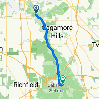
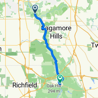
Rockridge Cleveland to Lake Erie and Back
A cycling route starting in Valley View, Ohio, United States.
Overview
About this route
- 3 h 7 min
- Duration
- 47.5 km
- Distance
- 275 m
- Ascent
- 273 m
- Descent
- 15.3 km/h
- Avg. speed
- 206 m
- Max. altitude
Route quality
Waytypes & surfaces along the route
Waytypes
Cycleway
46.5 km
(98 %)
Quiet road
1 km
(2 %)
Undefined
0 km
(<1 %)
Surfaces
Paved
37.4 km
(79 %)
Unpaved
6.9 km
(15 %)
Asphalt
19.8 km
(42 %)
Paved (undefined)
15.4 km
(32 %)
Continue with Bikemap
Use, edit, or download this cycling route
You would like to ride Rockridge Cleveland to Lake Erie and Back or customize it for your own trip? Here is what you can do with this Bikemap route:
Free features
- Save this route as favorite or in collections
- Copy & plan your own version of this route
- Sync your route with Garmin or Wahoo
Premium features
Free trial for 3 days, or one-time payment. More about Bikemap Premium.
- Navigate this route on iOS & Android
- Export a GPX / KML file of this route
- Create your custom printout (try it for free)
- Download this route for offline navigation
Discover more Premium features.
Get Bikemap PremiumFrom our community
Other popular routes starting in Valley View
 Slow ride in Hudson
- Distance
- 18 km
- Ascent
- 117 m
- Descent
- 81 m
- Location
- Valley View, Ohio, United States
 Independence to Independence
- Distance
- 13.2 km
- Ascent
- 16 m
- Descent
- 17 m
- Location
- Valley View, Ohio, United States
 From Cleveland to Peninsula
- Distance
- 18 km
- Ascent
- 103 m
- Descent
- 80 m
- Location
- Valley View, Ohio, United States
 9900–9962 Hillside Rd, Valley View to 9900–9962 Hillside Rd, Valley View
- Distance
- 48 km
- Ascent
- 531 m
- Descent
- 529 m
- Location
- Valley View, Ohio, United States
 30th B Day Bike Bonanza
- Distance
- 88.9 km
- Ascent
- 138 m
- Descent
- 135 m
- Location
- Valley View, Ohio, United States
 Canal Rd, Valley View to Peninsula
- Distance
- 18.3 km
- Ascent
- 35 m
- Descent
- 10 m
- Location
- Valley View, Ohio, United States
 Ohio Bike Trip Day 1
- Distance
- 85.2 km
- Ascent
- 292 m
- Descent
- 124 m
- Location
- Valley View, Ohio, United States
 Rockridge Cleveland to Lake Erie and Back
- Distance
- 47.5 km
- Ascent
- 275 m
- Descent
- 273 m
- Location
- Valley View, Ohio, United States
Open it in the app