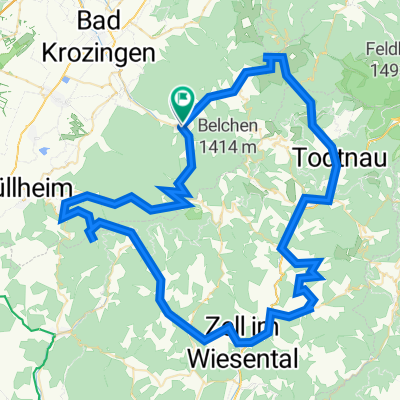
Belchen-Haldenhof_60km_1600hm
- 61.4 km
- 1,523 m
- 1,523 m
- Münstertal, Black Forest, Baden-Wurttemberg, Germany
A cycling route starting in Münstertal, Black Forest, Baden-Wurttemberg, Germany.
Overview
Die anspruchsvolle Umrundung des Münstertäler Haupttals - gewürzt mit kultigen Einkehrmöglichkeiten, einem Panorama-Singeltrail-Abschnitt und einem Top-Trainingsprofil.
created this 6 months ago
Continue with Bikemap
You would like to ride "King or Queen of the valley" or customize it for your own trip? Here is what you can do with this Bikemap route:
Free trial for 3 days, or one-time payment. More about Bikemap Premium.
Discover more Premium features.
Get Bikemap PremiumFrom our community
Open it in the app