

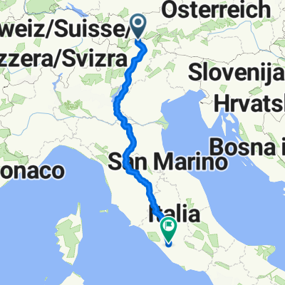
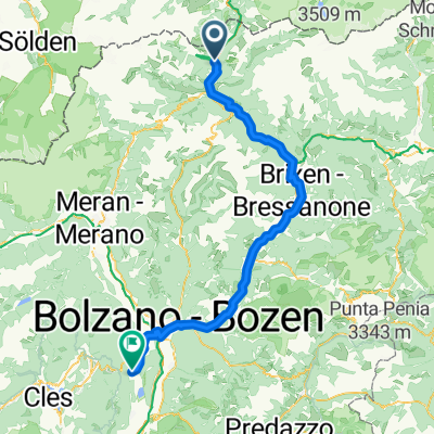
Route zu Lago Di Caldonazzo
A cycling route starting in Colle Isarco, Trentino-Alto Adige, Italy.
Overview
About this route
- 9 h 35 min
- Duration
- 163.7 km
- Distance
- 2,098 m
- Ascent
- 2,719 m
- Descent
- 17.1 km/h
- Avg. speed
- 1,085 m
- Max. altitude
Route quality
Waytypes & surfaces along the route
Waytypes
Cycleway
109.7 km
(67 %)
Quiet road
18 km
(11 %)
Surfaces
Paved
155.5 km
(95 %)
Unpaved
3.3 km
(2 %)
Asphalt
153.9 km
(94 %)
Paved (undefined)
1.6 km
(1 %)
Route highlights
Points of interest along the route
Point of interest after 0.4 km
Continue with Bikemap
Use, edit, or download this cycling route
You would like to ride Route zu Lago Di Caldonazzo or customize it for your own trip? Here is what you can do with this Bikemap route:
Free features
- Save this route as favorite or in collections
- Copy & plan your own version of this route
- Split it into stages to create a multi-day tour
- Sync your route with Garmin or Wahoo
Premium features
Free trial for 3 days, or one-time payment. More about Bikemap Premium.
- Navigate this route on iOS & Android
- Export a GPX / KML file of this route
- Create your custom printout (try it for free)
- Download this route for offline navigation
Discover more Premium features.
Get Bikemap PremiumFrom our community
Other popular routes starting in Colle Isarco
 Brenner-Florenz-Rom
- Distance
- 870.6 km
- Ascent
- 9,833 m
- Descent
- 10,901 m
- Location
- Colle Isarco, Trentino-Alto Adige, Italy
 Dolomitenumfahrung vs Uhr: BRENNER - Sterzing - Brixen - KLAUSEN - Bozen - TRIENT - Caldonazzo/Valsugana - FELTRE - Cesiomaggiore - BELLUNO - Longarone - PIEVE/
- Distance
- 477.3 km
- Ascent
- 1,735 m
- Descent
- 2,304 m
- Location
- Colle Isarco, Trentino-Alto Adige, Italy
 Route zu Lago Di Caldonazzo
- Distance
- 163.7 km
- Ascent
- 2,098 m
- Descent
- 2,719 m
- Location
- Colle Isarco, Trentino-Alto Adige, Italy
 Alpen 04 Gossensass-Klobenstein
- Distance
- 68.1 km
- Ascent
- 499 m
- Descent
- 861 m
- Location
- Colle Isarco, Trentino-Alto Adige, Italy
 Brenner - Taibon (recommended by you)
- Distance
- 143 km
- Ascent
- 1,421 m
- Descent
- 2,119 m
- Location
- Colle Isarco, Trentino-Alto Adige, Italy
 Große Brenner-Grenzkamm Runde - Große Brenner-Grenzkamm Runde
- Distance
- 64.6 km
- Ascent
- 2,371 m
- Descent
- 2,289 m
- Location
- Colle Isarco, Trentino-Alto Adige, Italy
 Gossensass - Leifers
- Distance
- 91.3 km
- Ascent
- 1,503 m
- Descent
- 2,355 m
- Location
- Colle Isarco, Trentino-Alto Adige, Italy
 Von Brenner bis Kaltern an der Weinstrass
- Distance
- 99 km
- Ascent
- 1,760 m
- Descent
- 2,391 m
- Location
- Colle Isarco, Trentino-Alto Adige, Italy
Open it in the app