

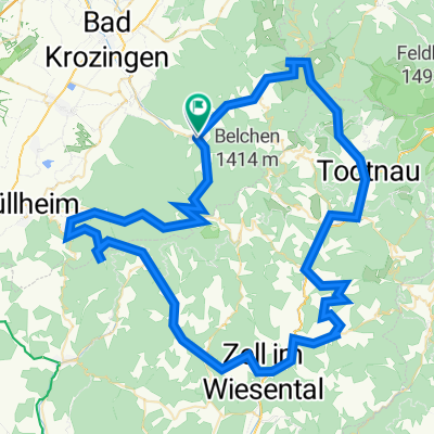
Von Münstertal/Schwarzwald bis Bad Krozingen
A cycling route starting in Münstertal, Black Forest, Baden-Wurttemberg, Germany.
Overview
About this route
- 31 min
- Duration
- 8.1 km
- Distance
- 3 m
- Ascent
- 105 m
- Descent
- 15.5 km/h
- Avg. speed
- 344 m
- Max. altitude
Route quality
Waytypes & surfaces along the route
Waytypes
Track
3.7 km
(46 %)
Quiet road
2.2 km
(27 %)
Surfaces
Paved
5.2 km
(64 %)
Unpaved
2.4 km
(30 %)
Asphalt
3.8 km
(47 %)
Gravel
2.3 km
(28 %)
Continue with Bikemap
Use, edit, or download this cycling route
You would like to ride Von Münstertal/Schwarzwald bis Bad Krozingen or customize it for your own trip? Here is what you can do with this Bikemap route:
Free features
- Save this route as favorite or in collections
- Copy & plan your own version of this route
- Sync your route with Garmin or Wahoo
Premium features
Free trial for 3 days, or one-time payment. More about Bikemap Premium.
- Navigate this route on iOS & Android
- Export a GPX / KML file of this route
- Create your custom printout (try it for free)
- Download this route for offline navigation
Discover more Premium features.
Get Bikemap PremiumFrom our community
Other popular routes starting in Münstertal
 Münstertal-Freiburg-St Peter-Titisee-Feldberg
- Distance
- 119.7 km
- Ascent
- 1,729 m
- Descent
- 1,729 m
- Location
- Münstertal, Black Forest, Baden-Wurttemberg, Germany
 Schwarzwald-Rennrad-Marathon 2018 (Bronze)
- Distance
- 118.5 km
- Ascent
- 2,937 m
- Descent
- 2,928 m
- Location
- Münstertal, Black Forest, Baden-Wurttemberg, Germany
 Schwarzwald-Rennrad-Marathon 2018 Bronze
- Distance
- 119.7 km
- Ascent
- 2,892 m
- Descent
- 2,883 m
- Location
- Münstertal, Black Forest, Baden-Wurttemberg, Germany
 "King or Queen of the valley"
- Distance
- 45.2 km
- Ascent
- 3,193 m
- Descent
- 3,190 m
- Location
- Münstertal, Black Forest, Baden-Wurttemberg, Germany
 SwS2023-Bronzeroute
- Distance
- 110.4 km
- Ascent
- 4,843 m
- Descent
- 4,837 m
- Location
- Münstertal, Black Forest, Baden-Wurttemberg, Germany
 Schwärze-Sirnitz_40km_1000hm
- Distance
- 38.9 km
- Ascent
- 1,285 m
- Descent
- 917 m
- Location
- Münstertal, Black Forest, Baden-Wurttemberg, Germany
 Von Münstertal/Schwarzwald bis Bad Krozingen
- Distance
- 8.1 km
- Ascent
- 3 m
- Descent
- 105 m
- Location
- Münstertal, Black Forest, Baden-Wurttemberg, Germany
 Münstertal-Tegernau-Gresgen-Pfaffenberg-Frönd-Utzenfeld-WiedenerEck
- Distance
- 71 km
- Ascent
- 3,044 m
- Descent
- 3,045 m
- Location
- Münstertal, Black Forest, Baden-Wurttemberg, Germany
Open it in the app