

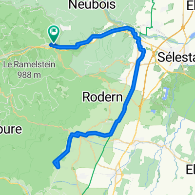
Route Lièpvre-Schlossberg
A cycling route starting in Lièpvre, Grand Est, France.
Overview
About this route
- 1 h 18 min
- Duration
- 13.2 km
- Distance
- 606 m
- Ascent
- 599 m
- Descent
- 10.2 km/h
- Avg. speed
- 687 m
- Max. altitude

Route quality
Waytypes & surfaces along the route
Waytypes
Track
8.2 km
(62 %)
Road
2.7 km
(20 %)
Surfaces
Paved
1.7 km
(13 %)
Unpaved
6.3 km
(47 %)
Ground
4.5 km
(34 %)
Unpaved (undefined)
1.5 km
(11 %)
Continue with Bikemap
Use, edit, or download this cycling route
You would like to ride Route Lièpvre-Schlossberg or customize it for your own trip? Here is what you can do with this Bikemap route:
Free features
- Save this route as favorite or in collections
- Copy & plan your own version of this route
- Sync your route with Garmin or Wahoo
Premium features
Free trial for 3 days, or one-time payment. More about Bikemap Premium.
- Navigate this route on iOS & Android
- Export a GPX / KML file of this route
- Create your custom printout (try it for free)
- Download this route for offline navigation
Discover more Premium features.
Get Bikemap PremiumFrom our community
Other popular routes starting in Lièpvre
 Liepvre / Munster
- Distance
- 96 km
- Ascent
- 1,409 m
- Descent
- 1,369 m
- Location
- Lièpvre, Grand Est, France
 Route Lièpvre-Haute Koenigsbourg
- Distance
- 23.3 km
- Ascent
- 863 m
- Descent
- 863 m
- Location
- Lièpvre, Grand Est, France
 F_Vogesen-du-Val-d-Argent_LR-58km-2140hm
- Distance
- 58.3 km
- Ascent
- 2,586 m
- Descent
- 2,584 m
- Location
- Lièpvre, Grand Est, France
 Route zu Camping du Haut Koenigsbourg
- Distance
- 59 km
- Ascent
- 510 m
- Descent
- 509 m
- Location
- Lièpvre, Grand Est, France
 Route Lièpvre-Schlossberg
- Distance
- 13.2 km
- Ascent
- 606 m
- Descent
- 599 m
- Location
- Lièpvre, Grand Est, France
 Liepvre / Munster
- Distance
- 109.7 km
- Ascent
- 1,408 m
- Descent
- 1,368 m
- Location
- Lièpvre, Grand Est, France
 Liepvre / Ribeauville / Riquewhir
- Distance
- 62.2 km
- Ascent
- 1,042 m
- Descent
- 1,187 m
- Location
- Lièpvre, Grand Est, France
 Liepvre Mt.Ste. Odile
- Distance
- 76.9 km
- Ascent
- 1,117 m
- Descent
- 1,115 m
- Location
- Lièpvre, Grand Est, France
Open it in the app