

VR16 Le Pouzin-Pracomtal.kml - VR16 Le Pouzin-Pracomtal.kml_VR16 Le Pouzin-Pracomtal
A cycling route starting in Le Pouzin, Auvergne-Rhône-Alpes, France.
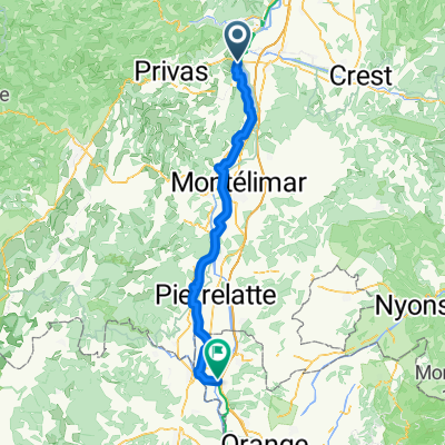
Overview
About this route
Converted from a KML file KML2GPX.COM - This is track no: 1
- -:--
- Duration
- 30.2 km
- Distance
- 154 m
- Ascent
- 168 m
- Descent
- ---
- Avg. speed
- 124 m
- Max. altitude

Continue with Bikemap
Use, edit, or download this cycling route
You would like to ride VR16 Le Pouzin-Pracomtal.kml - VR16 Le Pouzin-Pracomtal.kml_VR16 Le Pouzin-Pracomtal or customize it for your own trip? Here is what you can do with this Bikemap route:
Free features
- Save this route as favorite or in collections
- Copy & plan your own version of this route
- Sync your route with Garmin or Wahoo
Premium features
Free trial for 3 days, or one-time payment. More about Bikemap Premium.
- Navigate this route on iOS & Android
- Export a GPX / KML file of this route
- Create your custom printout (try it for free)
- Download this route for offline navigation
Discover more Premium features.
Get Bikemap PremiumFrom our community
Other popular routes starting in Le Pouzin
 Stage 8 b: Le Pouzin - Orange
- Distance
- 90.9 km
- Ascent
- 0 m
- Descent
- 0 m
- Location
- Le Pouzin, Auvergne-Rhône-Alpes, France
 VR16 Le Pouzin-Pracomtal.kml - VR16 Le Pouzin-Pracomtal.kml_VR16 Le Pouzin-Pracomtal
- Distance
- 30.2 km
- Ascent
- 154 m
- Descent
- 168 m
- Location
- Le Pouzin, Auvergne-Rhône-Alpes, France
 Le Pouzin - Beauchastel
- Distance
- 26.1 km
- Ascent
- 97 m
- Descent
- 57 m
- Location
- Le Pouzin, Auvergne-Rhône-Alpes, France
 FR_0113
- Distance
- 95.9 km
- Ascent
- 41 m
- Descent
- 87 m
- Location
- Le Pouzin, Auvergne-Rhône-Alpes, France
 Étape 4 - Via Rhône (Le Pouzin - Pont-Saint-Esprit)
- Distance
- 74.6 km
- Ascent
- 52 m
- Descent
- 88 m
- Location
- Le Pouzin, Auvergne-Rhône-Alpes, France
 Le Pouzin-Les Tourrettes
- Distance
- 10.8 km
- Ascent
- 27 m
- Descent
- 30 m
- Location
- Le Pouzin, Auvergne-Rhône-Alpes, France
 pouzin la voulte
- Distance
- 9.5 km
- Ascent
- 27 m
- Descent
- 14 m
- Location
- Le Pouzin, Auvergne-Rhône-Alpes, France
 Le Pouzin - Mondragon
- Distance
- 75.8 km
- Ascent
- 267 m
- Descent
- 319 m
- Location
- Le Pouzin, Auvergne-Rhône-Alpes, France
Open it in the app