
RTF Berlin Total 2015 1. Runde
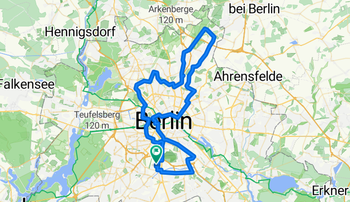
A cycling route starting in Schöneberg, State of Berlin, Germany.
Overview
About this route
RTF Veranstaltung
Veranstalter Schöneberger RV Iduna 1910 Fahrt im geschlossenen Verband - Helmpflicht- -:--
- Duration
- 78.1 km
- Distance
- 106 m
- Ascent
- 111 m
- Descent
- ---
- Avg. speed
- 64 m
- Max. altitude

Route quality
Waytypes & surfaces along the route
Waytypes
Busy road
32.2 km
(41 %)
Quiet road
18.9 km
(24 %)
Surfaces
Paved
75.2 km
(96 %)
Unpaved
0.8 km
(1 %)
Asphalt
65.5 km
(84 %)
Paving stones
8.3 km
(11 %)
Continue with Bikemap
Use, edit, or download this cycling route
You would like to ride RTF Berlin Total 2015 1. Runde or customize it for your own trip? Here is what you can do with this Bikemap route:
Free features
- Save this route as favorite or in collections
- Copy & plan your own version of this route
- Sync your route with Garmin or Wahoo
Premium features
Free trial for 3 days, or one-time payment. More about Bikemap Premium.
- Navigate this route on iOS & Android
- Export a GPX / KML file of this route
- Create your custom printout (try it for free)
- Download this route for offline navigation
Discover more Premium features.
Get Bikemap PremiumFrom our community
Other popular routes starting in Schöneberg
 RTF Berlin Total 2015 1. Runde
- Distance
- 78.1 km
- Ascent
- 106 m
- Descent
- 111 m
- Location
- Schöneberg, State of Berlin, Germany
 Südrunde via Fuchsberg, Kleinbeeren, Lankwitz
- Distance
- 62.4 km
- Ascent
- 83 m
- Descent
- 85 m
- Location
- Schöneberg, State of Berlin, Germany
 Zur Pizza nach Mittenwalde
- Distance
- 105 km
- Ascent
- 131 m
- Descent
- 127 m
- Location
- Schöneberg, State of Berlin, Germany
 Südkreuz -> Fuchsberg -> Mittenwalde -> Genshagen -> Lankwitz -> Südkreuz
- Distance
- 102.5 km
- Ascent
- 114 m
- Descent
- 110 m
- Location
- Schöneberg, State of Berlin, Germany
 Morgenrunde
- Distance
- 42.7 km
- Ascent
- 209 m
- Descent
- 208 m
- Location
- Schöneberg, State of Berlin, Germany
 Südkreuz -> Fuchsberg -> Mittenwalde -> Genshagen -> Lankwitz -> Südkreuz
- Distance
- 102.4 km
- Ascent
- 110 m
- Descent
- 107 m
- Location
- Schöneberg, State of Berlin, Germany
 Südkreuz - Mittenwalde - Zossen - Löwenbruch - Südkreuz
- Distance
- 87.8 km
- Ascent
- 137 m
- Descent
- 137 m
- Location
- Schöneberg, State of Berlin, Germany
 Südkreuz - Gröben - Teltowkanalradweg - Innsbrucker Platz
- Distance
- 78 km
- Ascent
- 117 m
- Descent
- 118 m
- Location
- Schöneberg, State of Berlin, Germany
Open it in the app