

Čertov kameň 433 m.n.m.
A cycling route starting in Medzilaborce, Prešov Region, Slovakia.
Overview
About this route
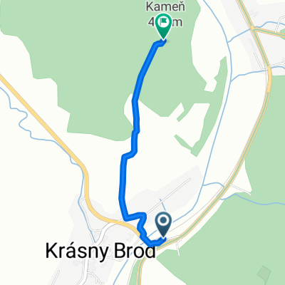
The green tourist trail to Čertov kameň starts at the train stop in Krásny Brod, from where you can cross a footbridge over the Laborec river to the opposite bank. The route continues ascending via a panel road between the church and the new mourning house. Then it proceeds freely across a meadow and a narrow strip of forest where there is a forest road, and again across a meadow up to the summit where there is an Orthodox cross, an information board, a campfire site, and at the very summit the Čertov kameň and an information board of the forestry educational trail.
- -:--
- Duration
- 1.6 km
- Distance
- 142 m
- Ascent
- 15 m
- Descent
- ---
- Avg. speed
- ---
- Max. altitude
Route highlights
Points of interest along the route
Point of interest after 1.5 km
drevený kríž, ohnisko s lavičkami a stolom, informačná tabuľa
Continue with Bikemap
Use, edit, or download this cycling route
You would like to ride Čertov kameň 433 m.n.m. or customize it for your own trip? Here is what you can do with this Bikemap route:
Free features
- Save this route as favorite or in collections
- Copy & plan your own version of this route
- Sync your route with Garmin or Wahoo
Premium features
Free trial for 3 days, or one-time payment. More about Bikemap Premium.
- Navigate this route on iOS & Android
- Export a GPX / KML file of this route
- Create your custom printout (try it for free)
- Download this route for offline navigation
Discover more Premium features.
Get Bikemap PremiumFrom our community
Other popular routes starting in Medzilaborce
 Cyklotrek Balnica
- Distance
- 79.8 km
- Ascent
- 865 m
- Descent
- 871 m
- Location
- Medzilaborce, Prešov Region, Slovakia
 Cyklotrek Mikov
- Distance
- 64 km
- Ascent
- 739 m
- Descent
- 749 m
- Location
- Medzilaborce, Prešov Region, Slovakia
 Cyklotrek Jasliska -Jasiel
- Distance
- 50.1 km
- Ascent
- 534 m
- Descent
- 528 m
- Location
- Medzilaborce, Prešov Region, Slovakia
 Čertov kameň 433 m.n.m.
- Distance
- 1.6 km
- Ascent
- 142 m
- Descent
- 15 m
- Location
- Medzilaborce, Prešov Region, Slovakia
 Čertov kameň
- Distance
- 1.6 km
- Ascent
- 142 m
- Descent
- 15 m
- Location
- Medzilaborce, Prešov Region, Slovakia
 Medzilaborce - Komancza
- Distance
- 23.3 km
- Ascent
- 459 m
- Descent
- 318 m
- Location
- Medzilaborce, Prešov Region, Slovakia
 Cyklotrek Brody
- Distance
- 62 km
- Ascent
- 647 m
- Descent
- 645 m
- Location
- Medzilaborce, Prešov Region, Slovakia
 Medzilaborce - Sanok MTB
- Distance
- 67.3 km
- Ascent
- 1,509 m
- Descent
- 1,546 m
- Location
- Medzilaborce, Prešov Region, Slovakia
Open it in the app