
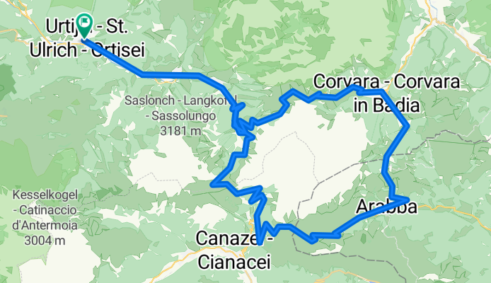
*** Sella Ronda (RB 075-2320)
A cycling route starting in Urtijëi, Trentino-Alto Adige, Italy.
Overview
About this route
Die Sella Ronda, gefahren beim Sella Ronda Bike Day 2012 (entgegen dem Uhrzeigersinn).
Landschaftlich eine der schönsten Rennradtouren die man sich vorstellen kann!!! Start und Ziel in St. Ulrich / Ortisei.- -:--
- Duration
- 75.4 km
- Distance
- 2,189 m
- Ascent
- 2,189 m
- Descent
- ---
- Avg. speed
- ---
- Max. altitude
Route quality
Waytypes & surfaces along the route
Waytypes
Busy road
53.6 km
(71 %)
Quiet road
10 km
(13 %)
Surfaces
Paved
66.3 km
(88 %)
Unpaved
1.7 km
(2 %)
Asphalt
65.8 km
(87 %)
Gravel
1 km
(1 %)
Continue with Bikemap
Use, edit, or download this cycling route
You would like to ride *** Sella Ronda (RB 075-2320) or customize it for your own trip? Here is what you can do with this Bikemap route:
Free features
- Save this route as favorite or in collections
- Copy & plan your own version of this route
- Sync your route with Garmin or Wahoo
Premium features
Free trial for 3 days, or one-time payment. More about Bikemap Premium.
- Navigate this route on iOS & Android
- Export a GPX / KML file of this route
- Create your custom printout (try it for free)
- Download this route for offline navigation
Discover more Premium features.
Get Bikemap PremiumFrom our community
Other popular routes starting in Urtijëi
 Plattkofelrunde ohne
- Distance
- 22.9 km
- Ascent
- 893 m
- Descent
- 893 m
- Location
- Urtijëi, Trentino-Alto Adige, Italy
 seiser alm - st. ulrich
- Distance
- 24.3 km
- Ascent
- 383 m
- Descent
- 1,161 m
- Location
- Urtijëi, Trentino-Alto Adige, Italy
 AanloopErbe
- Distance
- 21.2 km
- Ascent
- 63 m
- Descent
- 828 m
- Location
- Urtijëi, Trentino-Alto Adige, Italy
 SellaRondaBikeDay
- Distance
- 79.6 km
- Ascent
- 2,237 m
- Descent
- 2,240 m
- Location
- Urtijëi, Trentino-Alto Adige, Italy
 tour 190713 seiseralm
- Distance
- 38.8 km
- Ascent
- 1,248 m
- Descent
- 1,250 m
- Location
- Urtijëi, Trentino-Alto Adige, Italy
 Ortisei-Castelrotto, linksom
- Distance
- 38.7 km
- Ascent
- 1,123 m
- Descent
- 1,120 m
- Location
- Urtijëi, Trentino-Alto Adige, Italy
 Streda Sneton, Ortisei to Via Guglielmo Marconi, Cortina d'Ampezzo
- Distance
- 102.7 km
- Ascent
- 5,133 m
- Descent
- 5,144 m
- Location
- Urtijëi, Trentino-Alto Adige, Italy
 ValG_SellaClock
- Distance
- 67.3 km
- Ascent
- 1,032 m
- Descent
- 2,342 m
- Location
- Urtijëi, Trentino-Alto Adige, Italy
Open it in the app