

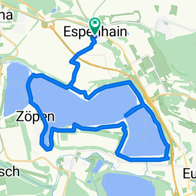
Hainer See nach Zwenkau
A cycling route starting in Espenhain, Saxony, Germany.
Overview
About this route
- 58 min
- Duration
- 16.4 km
- Distance
- 36 m
- Ascent
- 32 m
- Descent
- 16.8 km/h
- Avg. speed
- 147 m
- Max. altitude
Route quality
Waytypes & surfaces along the route
Waytypes
Path
8 km
(49 %)
Quiet road
4.3 km
(26 %)
Surfaces
Paved
11.6 km
(71 %)
Unpaved
1.1 km
(7 %)
Asphalt
11.5 km
(70 %)
Gravel
0.5 km
(3 %)
Continue with Bikemap
Use, edit, or download this cycling route
You would like to ride Hainer See nach Zwenkau or customize it for your own trip? Here is what you can do with this Bikemap route:
Free features
- Save this route as favorite or in collections
- Copy & plan your own version of this route
- Sync your route with Garmin or Wahoo
Premium features
Free trial for 3 days, or one-time payment. More about Bikemap Premium.
- Navigate this route on iOS & Android
- Export a GPX / KML file of this route
- Create your custom printout (try it for free)
- Download this route for offline navigation
Discover more Premium features.
Get Bikemap PremiumFrom our community
Other popular routes starting in Espenhain
 Strandweg, Neukieritzsch nach Hainweg, Neukieritzsch
- Distance
- 15.9 km
- Ascent
- 390 m
- Descent
- 371 m
- Location
- Espenhain, Saxony, Germany
 Thielrunde 2015
- Distance
- 39 km
- Ascent
- 105 m
- Descent
- 104 m
- Location
- Espenhain, Saxony, Germany
 Rundkurs Hainer See
- Distance
- 42.9 km
- Ascent
- 122 m
- Descent
- 125 m
- Location
- Espenhain, Saxony, Germany
 Kollegentour
- Distance
- 35.2 km
- Ascent
- 86 m
- Descent
- 83 m
- Location
- Espenhain, Saxony, Germany
 Um den Hainer See
- Distance
- 22.2 km
- Ascent
- 108 m
- Descent
- 107 m
- Location
- Espenhain, Saxony, Germany
 Hainer Seen über Stock & Stein
- Distance
- 28.1 km
- Ascent
- 56 m
- Descent
- 60 m
- Location
- Espenhain, Saxony, Germany

 Galgenweg, Rötha nach Galgenweg, Rötha
- Distance
- 23.4 km
- Ascent
- 99 m
- Descent
- 107 m
- Location
- Espenhain, Saxony, Germany
Open it in the app