

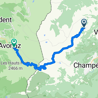
04/06 | Hotel National a Royal Savoy
A cycling route starting in Champéry, Valais, Switzerland.
Overview
About this route
- 5 h 5 min
- Duration
- 74 km
- Distance
- 770 m
- Ascent
- 1,418 m
- Descent
- 14.6 km/h
- Avg. speed
- 1,063 m
- Max. altitude

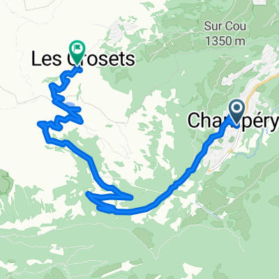
Route quality
Waytypes & surfaces along the route
Waytypes
Quiet road
21.5 km
(29 %)
Access road
11.8 km
(16 %)
Surfaces
Paved
57 km
(77 %)
Unpaved
0.7 km
(1 %)
Asphalt
54.8 km
(74 %)
Paved (undefined)
2.2 km
(3 %)
Continue with Bikemap
Use, edit, or download this cycling route
You would like to ride 04/06 | Hotel National a Royal Savoy or customize it for your own trip? Here is what you can do with this Bikemap route:
Free features
- Save this route as favorite or in collections
- Copy & plan your own version of this route
- Sync your route with Garmin or Wahoo
Premium features
Free trial for 3 days, or one-time payment. More about Bikemap Premium.
- Navigate this route on iOS & Android
- Export a GPX / KML file of this route
- Create your custom printout (try it for free)
- Download this route for offline navigation
Discover more Premium features.
Get Bikemap PremiumFrom our community
Other popular routes starting in Champéry
 Tout droit à l'intérieur Val-d'Illiez
- Distance
- 14.5 km
- Ascent
- 0 m
- Descent
- 0 m
- Location
- Champéry, Valais, Switzerland
 Rue Gamma, Champoussin nach Rue des Traîneaux, Morzine
- Distance
- 14.5 km
- Ascent
- 861 m
- Descent
- 661 m
- Location
- Champéry, Valais, Switzerland
 Champery - Champery
- Distance
- 124.4 km
- Ascent
- 2,244 m
- Descent
- 2,249 m
- Location
- Champéry, Valais, Switzerland
 Route de la Fin, Champéry to Route des Crosets, Les Crosets
- Distance
- 11.6 km
- Ascent
- 829 m
- Descent
- 188 m
- Location
- Champéry, Valais, Switzerland
 Critérium du Dauphiné 2013 Stage 1
- Distance
- 124.9 km
- Ascent
- 2,262 m
- Descent
- 2,239 m
- Location
- Champéry, Valais, Switzerland
 Val-d'Illiez à Chemin de Vai l'Otau, Troistorrents
- Distance
- 31.4 km
- Ascent
- 899 m
- Descent
- 1,894 m
- Location
- Champéry, Valais, Switzerland
 04/06 | Hotel National a Royal Savoy
- Distance
- 74 km
- Ascent
- 770 m
- Descent
- 1,418 m
- Location
- Champéry, Valais, Switzerland
 29.Aug.2012 Chalet Onu-Trailabfahrt nach Champery-Lac de Antème-Champery-Chalet Onu
- Distance
- 42.4 km
- Ascent
- 1,889 m
- Descent
- 1,900 m
- Location
- Champéry, Valais, Switzerland
Open it in the app