
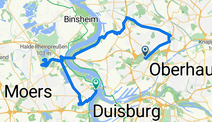
Grüner Pfad, Duisburg nach Königstraße, Duisburg
A cycling route starting in Meiderich, North Rhine-Westphalia, Germany.
Overview
About this route
- 3 h 12 min
- Duration
- 32.6 km
- Distance
- 165 m
- Ascent
- 160 m
- Descent
- 10.2 km/h
- Avg. speed
- 96 m
- Avg. speed
Route quality
Waytypes & surfaces along the route
Waytypes
Path
14.7 km
(45 %)
Quiet road
8.9 km
(27 %)
Surfaces
Paved
13.5 km
(41 %)
Unpaved
12.6 km
(39 %)
Gravel
11.7 km
(36 %)
Asphalt
10.4 km
(32 %)
Continue with Bikemap
Use, edit, or download this cycling route
You would like to ride Grüner Pfad, Duisburg nach Königstraße, Duisburg or customize it for your own trip? Here is what you can do with this Bikemap route:
Free features
- Save this route as favorite or in collections
- Copy & plan your own version of this route
- Sync your route with Garmin or Wahoo
Premium features
Free trial for 3 days, or one-time payment. More about Bikemap Premium.
- Navigate this route on iOS & Android
- Export a GPX / KML file of this route
- Create your custom printout (try it for free)
- Download this route for offline navigation
Discover more Premium features.
Get Bikemap PremiumFrom our community
Other popular routes starting in Meiderich
 Duisburg Rundtour
- Distance
- 34.6 km
- Ascent
- 58 m
- Descent
- 55 m
- Location
- Meiderich, North Rhine-Westphalia, Germany
 Rheinberg
- Distance
- 18.7 km
- Ascent
- 25 m
- Descent
- 29 m
- Location
- Meiderich, North Rhine-Westphalia, Germany
 Langsame Fahrt in Oberhausen
- Distance
- 10 km
- Ascent
- 9 m
- Descent
- 9 m
- Location
- Meiderich, North Rhine-Westphalia, Germany
 Ruhrtalradweg
- Distance
- 226.5 km
- Ascent
- 798 m
- Descent
- 167 m
- Location
- Meiderich, North Rhine-Westphalia, Germany
 24h Duisburg
- Distance
- 7.8 km
- Ascent
- 42 m
- Descent
- 42 m
- Location
- Meiderich, North Rhine-Westphalia, Germany
 Emscher/Rhein-Herne-Kanal/Ruhr/ Rhein Runde
- Distance
- 43.1 km
- Ascent
- 101 m
- Descent
- 104 m
- Location
- Meiderich, North Rhine-Westphalia, Germany
 Ruhrtal-Baldeneysee-Runde 3
- Distance
- 62.4 km
- Ascent
- 185 m
- Descent
- 184 m
- Location
- Meiderich, North Rhine-Westphalia, Germany
 Rotbachrunde
- Distance
- 27.7 km
- Ascent
- 82 m
- Descent
- 69 m
- Location
- Meiderich, North Rhine-Westphalia, Germany
Open it in the app