

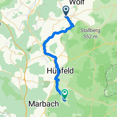
Niederaula
A cycling route starting in Eiterfeld, Hesse, Germany.
Overview
About this route
Niederaula
- 3 h 35 min
- Duration
- 63.3 km
- Distance
- 504 m
- Ascent
- 504 m
- Descent
- 17.7 km/h
- Avg. speed
- 367 m
- Max. altitude

Route quality
Waytypes & surfaces along the route
Waytypes
Path
20.9 km
(33 %)
Quiet road
18.3 km
(29 %)
Surfaces
Paved
55.7 km
(88 %)
Asphalt
48.7 km
(77 %)
Concrete
5.7 km
(9 %)
Continue with Bikemap
Use, edit, or download this cycling route
You would like to ride Niederaula or customize it for your own trip? Here is what you can do with this Bikemap route:
Free features
- Save this route as favorite or in collections
- Copy & plan your own version of this route
- Sync your route with Garmin or Wahoo
Premium features
Free trial for 3 days, or one-time payment. More about Bikemap Premium.
- Navigate this route on iOS & Android
- Export a GPX / KML file of this route
- Create your custom printout (try it for free)
- Download this route for offline navigation
Discover more Premium features.
Get Bikemap PremiumFrom our community
Other popular routes starting in Eiterfeld
 Haunetal Burgrunde 01
- Distance
- 34.1 km
- Ascent
- 669 m
- Descent
- 670 m
- Location
- Eiterfeld, Hesse, Germany
 Haubtweg, Eiterfeld nach Allmuser Straße, Hünfeld
- Distance
- 22.5 km
- Ascent
- 160 m
- Descent
- 137 m
- Location
- Eiterfeld, Hesse, Germany
 Buchenau Stopelsberg Buchenau
- Distance
- 16.7 km
- Ascent
- 305 m
- Descent
- 305 m
- Location
- Eiterfeld, Hesse, Germany
 Niederaula
- Distance
- 63.3 km
- Ascent
- 504 m
- Descent
- 504 m
- Location
- Eiterfeld, Hesse, Germany
 Haunetal-Kirchheim-HEF
- Distance
- 53.1 km
- Ascent
- 428 m
- Descent
- 422 m
- Location
- Eiterfeld, Hesse, Germany
 Haunetal-Schenklengsfeld-Bad Hersfeld- Haunetal
- Distance
- 40.4 km
- Ascent
- 281 m
- Descent
- 279 m
- Location
- Eiterfeld, Hesse, Germany
 Die Tour für´s Auge CLONED FROM ROUTE 1474923
- Distance
- 20.4 km
- Ascent
- 330 m
- Descent
- 330 m
- Location
- Eiterfeld, Hesse, Germany
 Schönau a.d.Brend 3-Tage 1
- Distance
- 86.2 km
- Ascent
- 916 m
- Descent
- 911 m
- Location
- Eiterfeld, Hesse, Germany
Open it in the app