

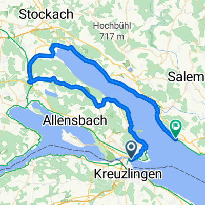
Rundfahrt Kreuzlingen - Bättershausen - Bommerweiher - Steckborn - Kreuzlingen
A cycling route starting in Kreuzlingen, Thurgau, Switzerland.
Overview
About this route
The first climb is steep (no cold muscles!). Above the railway crossing, on the left is a shooting range with a large parking lot = view back towards the Lake Constance panorama.
A short detour above the target wall to the left to a beautiful nature reserve with 3 ponds. The path north of the western swamp area is NOT!!! suitable for cycling!
North of the large Bommer pond, there is a rest area with benches, a fire pit, and fresh drinking water.
Before the bridge over the highway, there is a 'boulder garden' with glacial debris found during construction work.
At Hohrain (Wäldli), in the forest on the right, there is a (new) observation tower at the spot where Napoleon III had an observation and pleasure tower built.
On the left, the Thur valley and Alpine panorama on a clear day.
The descent to Steckborn is very steep and runs on a relatively busy road without a bike lane.
In Steckborn, there is a great recreational park by the lake near the boat dock. There is the option to take a URh boat to Konstanz and Kreuzlingen, or simply cross over to Reichenau or go to Stein am Rhein, Schaffhausen, or Gaienhofen, Hemmenhofen (timetables on URh.ch or BSB.de).
- 4 h 11 min
- Duration
- 71.5 km
- Distance
- 920 m
- Ascent
- 920 m
- Descent
- 17.1 km/h
- Avg. speed
- 630 m
- Max. altitude

Route quality
Waytypes & surfaces along the route
Waytypes
Quiet road
26.4 km
(37 %)
Track
15.7 km
(22 %)
Surfaces
Paved
60.7 km
(85 %)
Unpaved
7.1 km
(10 %)
Asphalt
59.3 km
(83 %)
Gravel
4.3 km
(6 %)
Continue with Bikemap
Use, edit, or download this cycling route
You would like to ride Rundfahrt Kreuzlingen - Bättershausen - Bommerweiher - Steckborn - Kreuzlingen or customize it for your own trip? Here is what you can do with this Bikemap route:
Free features
- Save this route as favorite or in collections
- Copy & plan your own version of this route
- Sync your route with Garmin or Wahoo
Premium features
Free trial for 3 days, or one-time payment. More about Bikemap Premium.
- Navigate this route on iOS & Android
- Export a GPX / KML file of this route
- Create your custom printout (try it for free)
- Download this route for offline navigation
Discover more Premium features.
Get Bikemap PremiumFrom our community
Other popular routes starting in Kreuzlingen
 Bodenseeradweg ab Friedrichshafen
- Distance
- 255.9 km
- Ascent
- 268 m
- Descent
- 268 m
- Location
- Kreuzlingen, Thurgau, Switzerland
 Samstagmittagrunde
- Distance
- 46.3 km
- Ascent
- 288 m
- Descent
- 291 m
- Location
- Kreuzlingen, Thurgau, Switzerland
 Untersee
- Distance
- 70.5 km
- Ascent
- 218 m
- Descent
- 219 m
- Location
- Kreuzlingen, Thurgau, Switzerland
 Abendrunde Thurgau
- Distance
- 40 km
- Ascent
- 252 m
- Descent
- 253 m
- Location
- Kreuzlingen, Thurgau, Switzerland
 Tour 3/34 km / Insel-Reichenau
- Distance
- 33.9 km
- Ascent
- 134 m
- Descent
- 133 m
- Location
- Kreuzlingen, Thurgau, Switzerland
 Von Konstanz um den Überlinger See nach Meersburg (Bodensee)
- Distance
- 64.9 km
- Ascent
- 318 m
- Descent
- 316 m
- Location
- Kreuzlingen, Thurgau, Switzerland
 Rundfahrt Kreuzlingen - Bättershausen - Bommerweiher - Steckborn - Kreuzlingen
- Distance
- 71.5 km
- Ascent
- 920 m
- Descent
- 920 m
- Location
- Kreuzlingen, Thurgau, Switzerland
 Rund um den Ottoberg
- Distance
- 45.7 km
- Ascent
- 344 m
- Descent
- 341 m
- Location
- Kreuzlingen, Thurgau, Switzerland
Open it in the app