

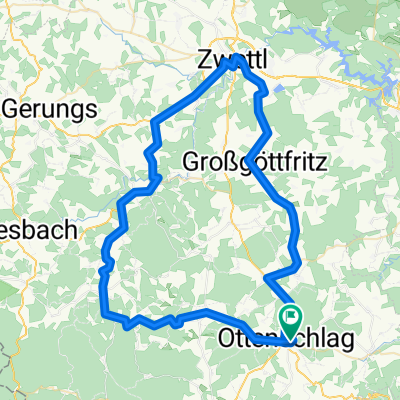
Route nach Linz
A cycling route starting in Ottenschlag, Lower Austria, Austria.
Overview
About this route
- 6 h 42 min
- Duration
- 113.6 km
- Distance
- 1,303 m
- Ascent
- 1,881 m
- Descent
- 16.9 km/h
- Avg. speed
- 950 m
- Max. altitude

Route quality
Waytypes & surfaces along the route
Waytypes
Cycleway
43.9 km
(39 %)
Road
28.9 km
(25 %)
Surfaces
Paved
69.4 km
(61 %)
Unpaved
5.4 km
(5 %)
Asphalt
67 km
(59 %)
Gravel
3.1 km
(3 %)
Continue with Bikemap
Use, edit, or download this cycling route
You would like to ride Route nach Linz or customize it for your own trip? Here is what you can do with this Bikemap route:
Free features
- Save this route as favorite or in collections
- Copy & plan your own version of this route
- Split it into stages to create a multi-day tour
- Sync your route with Garmin or Wahoo
Premium features
Free trial for 3 days, or one-time payment. More about Bikemap Premium.
- Navigate this route on iOS & Android
- Export a GPX / KML file of this route
- Create your custom printout (try it for free)
- Download this route for offline navigation
Discover more Premium features.
Get Bikemap PremiumFrom our community
Other popular routes starting in Ottenschlag
 Ottenschlag-Schönbach-Zwettl-Engelbrechts-Ottenschlag
- Distance
- 71.9 km
- Ascent
- 1,207 m
- Descent
- 1,213 m
- Location
- Ottenschlag, Lower Austria, Austria
 Route nach Linz
- Distance
- 113.6 km
- Ascent
- 1,303 m
- Descent
- 1,881 m
- Location
- Ottenschlag, Lower Austria, Austria
 Kombitour 17 & 19
- Distance
- 46.3 km
- Ascent
- 953 m
- Descent
- 950 m
- Location
- Ottenschlag, Lower Austria, Austria
 Ottenschlag_Traunstein 1
- Distance
- 38.4 km
- Ascent
- 625 m
- Descent
- 623 m
- Location
- Ottenschlag, Lower Austria, Austria
 Kombitour 10 & 17 & 4
- Distance
- 40.9 km
- Ascent
- 657 m
- Descent
- 658 m
- Location
- Ottenschlag, Lower Austria, Austria
 Waldviertler Hochlandweg CLONED FROM ROUTE 44449
- Distance
- 72.9 km
- Ascent
- 780 m
- Descent
- 780 m
- Location
- Ottenschlag, Lower Austria, Austria
 Ottenschlag leicht
- Distance
- 28.3 km
- Ascent
- 310 m
- Descent
- 318 m
- Location
- Ottenschlag, Lower Austria, Austria
 Ottenschlag - Seiberer
- Distance
- 44.7 km
- Ascent
- 968 m
- Descent
- 973 m
- Location
- Ottenschlag, Lower Austria, Austria
Open it in the app