

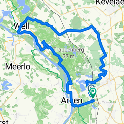
47 km vom Radwandertag 2012 Route 19
A cycling route starting in Straelen, North Rhine-Westphalia, Germany.
Overview
About this route
The route 19 of the Lower Rhine Cycling Day from July 1, 2012 has been shortened.
Reduced from originally 57.40 km to about 47.00 km. The starting and ending point is indicated here as Walbeck; it was originally Arcen. Aldekerk and the heathland landscape of Lingsfort have been removed and replaced by a part of the NRW route from Straelen.
This is the afternoon tour of ADFC-Gelderland from 07.07.2012.
Start in Geldern at the Dragon Fountain at 14:00, through Vernum, Nieukerk, Eyll, Eyll Lake, a longer break in Straelen at the market (there is enough gastronomy here and larger groups also find sufficient, quick, supply and resting possibilities without prior reservation.). Continuing over the riding place Auel-Holt to Walbeck (part of the NRW route), back on route 19, it goes back via Pont to the starting point Geldern, arrival at around 18:00.
- -:--
- Duration
- 45.6 km
- Distance
- 51 m
- Ascent
- 53 m
- Descent
- ---
- Avg. speed
- ---
- Max. altitude
Route quality
Waytypes & surfaces along the route
Waytypes
Quiet road
22.8 km
(50 %)
Track
11.4 km
(25 %)
Surfaces
Paved
31.4 km
(69 %)
Unpaved
3.6 km
(8 %)
Asphalt
29.2 km
(64 %)
Paved (undefined)
2.3 km
(5 %)
Continue with Bikemap
Use, edit, or download this cycling route
You would like to ride 47 km vom Radwandertag 2012 Route 19 or customize it for your own trip? Here is what you can do with this Bikemap route:
Free features
- Save this route as favorite or in collections
- Copy & plan your own version of this route
- Sync your route with Garmin or Wahoo
Premium features
Free trial for 3 days, or one-time payment. More about Bikemap Premium.
- Navigate this route on iOS & Android
- Export a GPX / KML file of this route
- Create your custom printout (try it for free)
- Download this route for offline navigation
Discover more Premium features.
Get Bikemap PremiumFrom our community
Other popular routes starting in Straelen
 Cafe Schafstall Twisteden
- Distance
- 16.4 km
- Ascent
- 26 m
- Descent
- 49 m
- Location
- Straelen, North Rhine-Westphalia, Germany
 Arcen-Well
- Distance
- 43.1 km
- Ascent
- 130 m
- Descent
- 132 m
- Location
- Straelen, North Rhine-Westphalia, Germany
 47 km vom Radwandertag 2012 Route 19
- Distance
- 45.6 km
- Ascent
- 51 m
- Descent
- 53 m
- Location
- Straelen, North Rhine-Westphalia, Germany
 Seentour
- Distance
- 19.2 km
- Ascent
- 28 m
- Descent
- 42 m
- Location
- Straelen, North Rhine-Westphalia, Germany
 Viersen - Son en Breugel
- Distance
- 99.1 km
- Ascent
- 99 m
- Descent
- 117 m
- Location
- Straelen, North Rhine-Westphalia, Germany
 Heinz,Steyl-Kald. Strae.,54Km
- Distance
- 57.2 km
- Ascent
- 147 m
- Descent
- 148 m
- Location
- Straelen, North Rhine-Westphalia, Germany
 Tag 2 Straelen - Roermond
- Distance
- 44 km
- Ascent
- 80 m
- Descent
- 81 m
- Location
- Straelen, North Rhine-Westphalia, Germany
 Straelen nach Duisburg Tag 2
- Distance
- 46.2 km
- Ascent
- 127 m
- Descent
- 139 m
- Location
- Straelen, North Rhine-Westphalia, Germany
Open it in the app