
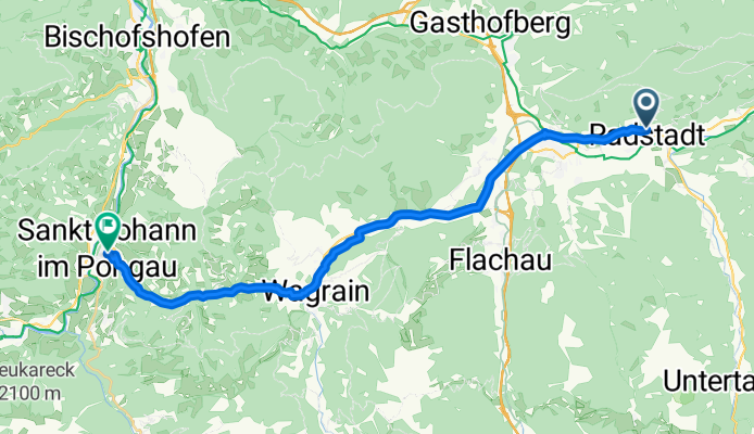
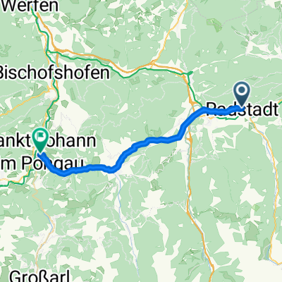
Radstadt-SanktJohannimPongau
A cycling route starting in Radstadt, Salzburg, Austria.
Overview
About this route
The other connection between the Ennsradweg and the Alpe-Adria-Radweg
- 1 h 33 min
- Duration
- 24.9 km
- Distance
- 227 m
- Ascent
- 467 m
- Descent
- 16.1 km/h
- Avg. speed
- 956 m
- Max. altitude

Route quality
Waytypes & surfaces along the route
Waytypes
Quiet road
5.2 km
(21 %)
Cycleway
5.2 km
(21 %)
Surfaces
Paved
15.7 km
(63 %)
Unpaved
3.5 km
(14 %)
Asphalt
15.7 km
(63 %)
Gravel
3.5 km
(14 %)
Undefined
5.7 km
(23 %)
Continue with Bikemap
Use, edit, or download this cycling route
You would like to ride Radstadt-SanktJohannimPongau or customize it for your own trip? Here is what you can do with this Bikemap route:
Free features
- Save this route as favorite or in collections
- Copy & plan your own version of this route
- Sync your route with Garmin or Wahoo
Premium features
Free trial for 3 days, or one-time payment. More about Bikemap Premium.
- Navigate this route on iOS & Android
- Export a GPX / KML file of this route
- Create your custom printout (try it for free)
- Download this route for offline navigation
Discover more Premium features.
Get Bikemap PremiumFrom our community
Other popular routes starting in Radstadt
 Höggenstraße, Radstadt to Roßbrandstraße, Radstadt
- Distance
- 29 km
- Ascent
- 1,619 m
- Descent
- 759 m
- Location
- Radstadt, Salzburg, Austria
 Girolibero: Ciclabile dell'Enns
- Distance
- 222.2 km
- Ascent
- 422 m
- Descent
- 976 m
- Location
- Radstadt, Salzburg, Austria
 Radstadt-SanktJohannimPongau
- Distance
- 24.9 km
- Ascent
- 227 m
- Descent
- 467 m
- Location
- Radstadt, Salzburg, Austria
 Höggenstraße, Radstadt to Schildlehen, Ramsau am Dachstein
- Distance
- 26 km
- Ascent
- 1,634 m
- Descent
- 951 m
- Location
- Radstadt, Salzburg, Austria
 Radstat_Enns_Linz
- Distance
- 237.9 km
- Ascent
- 244 m
- Descent
- 830 m
- Location
- Radstadt, Salzburg, Austria
 Ennsradweg
- Distance
- 233.9 km
- Ascent
- 278 m
- Descent
- 851 m
- Location
- Radstadt, Salzburg, Austria
 Schladming
- Distance
- 51.9 km
- Ascent
- 299 m
- Descent
- 318 m
- Location
- Radstadt, Salzburg, Austria
 Radstadt-Bürgerberg-Reitlehenrunde
- Distance
- 18.8 km
- Ascent
- 626 m
- Descent
- 627 m
- Location
- Radstadt, Salzburg, Austria
Open it in the app