
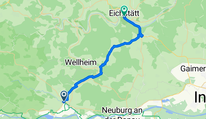
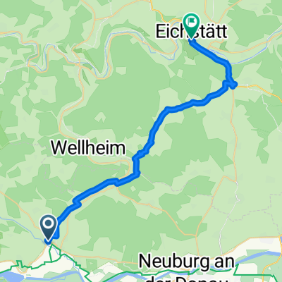
Unbenannte Route
A cycling route starting in Rennertshofen, Bavaria, Germany.
Overview
About this route
- 1 h 38 min
- Duration
- 27.3 km
- Distance
- 315 m
- Ascent
- 316 m
- Descent
- 16.7 km/h
- Avg. speed
- 519 m
- Max. altitude
Route quality
Waytypes & surfaces along the route
Waytypes
Path
9.7 km
(35 %)
Quiet road
9.1 km
(33 %)
Surfaces
Paved
21.2 km
(77 %)
Unpaved
5.1 km
(19 %)
Asphalt
21 km
(77 %)
Gravel
4.5 km
(17 %)
Continue with Bikemap
Use, edit, or download this cycling route
You would like to ride Unbenannte Route or customize it for your own trip? Here is what you can do with this Bikemap route:
Free features
- Save this route as favorite or in collections
- Copy & plan your own version of this route
- Sync your route with Garmin or Wahoo
Premium features
Free trial for 3 days, or one-time payment. More about Bikemap Premium.
- Navigate this route on iOS & Android
- Export a GPX / KML file of this route
- Create your custom printout (try it for free)
- Download this route for offline navigation
Discover more Premium features.
Get Bikemap PremiumFrom our community
Other popular routes starting in Rennertshofen
 Dohlenfelsenstraße 16, Wellheim nach St2047, Rennertshofen
- Distance
- 47.7 km
- Ascent
- 1,507 m
- Descent
- 1,504 m
- Location
- Rennertshofen, Bavaria, Germany
 5aa Rennertshofen Bad Gogging 71km
- Distance
- 70.2 km
- Ascent
- 81 m
- Descent
- 120 m
- Location
- Rennertshofen, Bavaria, Germany
 Bertholzheim- Neuburg
- Distance
- 33.7 km
- Ascent
- 212 m
- Descent
- 212 m
- Location
- Rennertshofen, Bavaria, Germany
 Bergstrecke Links oder rechts herum
- Distance
- 45.6 km
- Ascent
- 730 m
- Descent
- 704 m
- Location
- Rennertshofen, Bavaria, Germany
 Bergstrecke Links oder rechts herum
- Distance
- 45.6 km
- Ascent
- 729 m
- Descent
- 703 m
- Location
- Rennertshofen, Bavaria, Germany
 Unbenannte Route
- Distance
- 27.3 km
- Ascent
- 315 m
- Descent
- 316 m
- Location
- Rennertshofen, Bavaria, Germany
 Bergstrecke Links oder rechts herum
- Distance
- 45.6 km
- Ascent
- 897 m
- Descent
- 883 m
- Location
- Rennertshofen, Bavaria, Germany
 Radltour Wellheim über Pfünz Eichstätt und Dollnstein zurück
- Distance
- 54.1 km
- Ascent
- 285 m
- Descent
- 284 m
- Location
- Rennertshofen, Bavaria, Germany
Open it in the app