

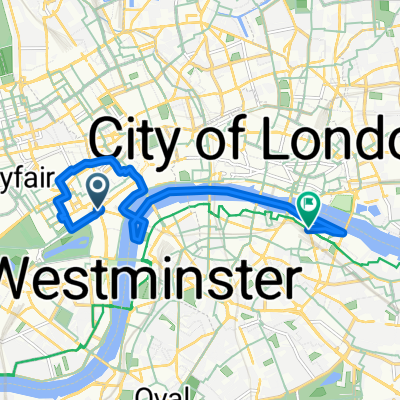
Mens Womens Olympic Cycle Road Race Route
A cycling route starting in London, England, United Kingdom.
Overview
About this route
2012 London Olympic
- -:--
- Duration
- 124.7 km
- Distance
- 574 m
- Ascent
- 577 m
- Descent
- ---
- Avg. speed
- ---
- Max. altitude

Route highlights
Points of interest along the route
Point of interest after 1.2 km
バッキンガム宮殿
Photo after 17.2 km
空撮写真route01.jpgはこのあたり上空から南南西を見わたしています。
Photo after 17.4 km
richmond_town.jpg
Point of interest after 25.5 km
鹿
Point of interest after 29.2 km
ヨットなどを描いてもグー。
Point of interest after 32.2 km
わりと平凡な住宅街……。 google street map などをご覧になって家並みを描いていただいてもいいと思います。
Photo after 34.1 km
バランス的にこのへんで1点写真用意しようと思っています。
Photo after 44 km
崩れた教会(ニューワーク・アウグスティニアン・プライオリー)
Photo after 55.2 km
ステイプル・レーン
Photo after 57.8 km
Shere_town.jpg
Point of interest after 57.8 km
Photo after 62.4 km
R_horses.jpg
Point of interest after 69.5 km
ドーキング(町名)
Photo after 73.8 km
ジグザグ・ロード
Point of interest after 74.2 km
ボックス・ヒル
Point of interest after 75.5 km
Photo after 75.5 km
Boxhill01-03.jpg ※最大の見所なので、写真3点で吹き出しコラムのようにしてください。
Photo after 78.2 km
R_Boxhill05.jpg
Photo after 81.5 km
millway.jpg
Point of interest after 87 km
レザーヘッド(町名)
Point of interest after 94.8 km
道にそって木立が多いイラスト
Photo after 96.1 km
Esher.jpg
Point of interest after 97.6 km
住宅街
Point of interest after 100.3 km
ブッシー・パーク(公園名)
Photo after 100.5 km
R_hamptoncourt.jpg ハンプトンコート宮殿
Point of interest after 102.8 km
テムズ川 ヨットなどを描いてもグー。
Photo after 103.1 km
Kingston_town.jpg
Point of interest after 103.2 km
キングストン・アポン・テムズ (町名)
Point of interest after 110 km
鹿
Point of interest after 121.2 km
テムズ川 イラストを描くならたとえばカッターボートとかが気分です。
Point of interest after 121.5 km
ハイドパーク(公園)
Continue with Bikemap
Use, edit, or download this cycling route
You would like to ride Mens Womens Olympic Cycle Road Race Route or customize it for your own trip? Here is what you can do with this Bikemap route:
Free features
- Save this route as favorite or in collections
- Copy & plan your own version of this route
- Split it into stages to create a multi-day tour
- Sync your route with Garmin or Wahoo
Premium features
Free trial for 3 days, or one-time payment. More about Bikemap Premium.
- Navigate this route on iOS & Android
- Export a GPX / KML file of this route
- Create your custom printout (try it for free)
- Download this route for offline navigation
Discover more Premium features.
Get Bikemap PremiumFrom our community
Other popular routes starting in London
 Mens Womens Olympic Cycle Road Race Route
- Distance
- 124.7 km
- Ascent
- 574 m
- Descent
- 577 m
- Location
- London, England, United Kingdom
 London Walk with Lucy and Sophie
- Distance
- 8.5 km
- Ascent
- 50 m
- Descent
- 50 m
- Location
- London, England, United Kingdom
 London to Amsterdam
- Distance
- 1,133.4 km
- Ascent
- 686 m
- Descent
- 710 m
- Location
- London, England, United Kingdom
 Olympic Route (minus Box Hill Laps)
- Distance
- 137.7 km
- Ascent
- 507 m
- Descent
- 502 m
- Location
- London, England, United Kingdom
 Burlington Arcade, London to Bridgewick Road, Southminster
- Distance
- 109.5 km
- Ascent
- 452 m
- Descent
- 483 m
- Location
- London, England, United Kingdom
 125 Oxford St, London to 14 Block D, Hertsmere Road, London
- Distance
- 10 km
- Ascent
- 24 m
- Descent
- 44 m
- Location
- London, England, United Kingdom
 Burlington Arcade, London to Willey, Presteigne
- Distance
- 300.9 km
- Ascent
- 2,930 m
- Descent
- 2,696 m
- Location
- London, England, United Kingdom
 228 Piccadilly, London to 5–9 Great Windmill St, London
- Distance
- 0.2 km
- Ascent
- 0 m
- Descent
- 4 m
- Location
- London, England, United Kingdom
Open it in the app