

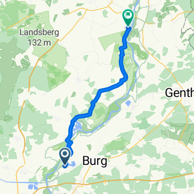
Route nach Tangermünde
A cycling route starting in Hohenwarthe, Saxony-Anhalt, Germany.
Overview
About this route
- 2 h 10 min
- Duration
- 43.4 km
- Distance
- 122 m
- Ascent
- 120 m
- Descent
- 20 km/h
- Avg. speed
- 56 m
- Max. altitude

Route quality
Waytypes & surfaces along the route
Waytypes
Track
18.2 km
(42 %)
Path
14.8 km
(34 %)
Surfaces
Paved
26.9 km
(62 %)
Unpaved
6.9 km
(16 %)
Asphalt
25.2 km
(58 %)
Ground
6.9 km
(16 %)
Continue with Bikemap
Use, edit, or download this cycling route
You would like to ride Route nach Tangermünde or customize it for your own trip? Here is what you can do with this Bikemap route:
Free features
- Save this route as favorite or in collections
- Copy & plan your own version of this route
- Sync your route with Garmin or Wahoo
Premium features
Free trial for 3 days, or one-time payment. More about Bikemap Premium.
- Navigate this route on iOS & Android
- Export a GPX / KML file of this route
- Create your custom printout (try it for free)
- Download this route for offline navigation
Discover more Premium features.
Get Bikemap PremiumFrom our community
Other popular routes starting in Hohenwarthe
 Route nach Tangermünde
- Distance
- 43.4 km
- Ascent
- 122 m
- Descent
- 120 m
- Location
- Hohenwarthe, Saxony-Anhalt, Germany
 Gildenberg/hohenwarte - Magdeburg Hbf
- Distance
- 17.8 km
- Ascent
- 64 m
- Descent
- 48 m
- Location
- Hohenwarthe, Saxony-Anhalt, Germany
 Elbstraße 66, Loitsche-Heinrichsberg nach Heideweg 38, Wolmirstedt
- Distance
- 15.2 km
- Ascent
- 24 m
- Descent
- 7 m
- Location
- Hohenwarthe, Saxony-Anhalt, Germany
 Elbe 12 Hohenwarthe-Tangermünde
- Distance
- 58.6 km
- Ascent
- 67 m
- Descent
- 74 m
- Location
- Hohenwarthe, Saxony-Anhalt, Germany
 Niegripp - Brandenburg Havel
- Distance
- 63 km
- Ascent
- 94 m
- Descent
- 100 m
- Location
- Hohenwarthe, Saxony-Anhalt, Germany
 Radtour DD-HH
- Distance
- 124.6 km
- Ascent
- 211 m
- Descent
- 243 m
- Location
- Hohenwarthe, Saxony-Anhalt, Germany
 5 Hohenwarthe-Barby 60
- Distance
- 60.4 km
- Ascent
- 183 m
- Descent
- 184 m
- Location
- Hohenwarthe, Saxony-Anhalt, Germany
 Hohenwarthe-Külzauer Forst-Möser Bahnhof
- Distance
- 5.6 km
- Ascent
- 41 m
- Descent
- 30 m
- Location
- Hohenwarthe, Saxony-Anhalt, Germany
Open it in the app