

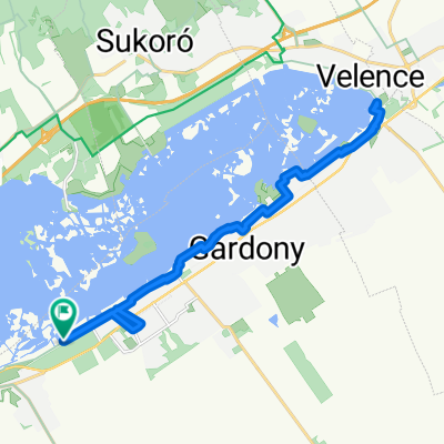
Budai út, Pákozd - Béke utca, Velence
A cycling route starting in Pákozd, Fejér, Hungary.
Overview
About this route
- 2 h 14 min
- Duration
- 19.2 km
- Distance
- 103 m
- Ascent
- 119 m
- Descent
- 8.6 km/h
- Avg. speed
- 143 m
- Max. altitude
Route photos


Continue with Bikemap
Use, edit, or download this cycling route
You would like to ride Budai út, Pákozd - Béke utca, Velence or customize it for your own trip? Here is what you can do with this Bikemap route:
Free features
- Save this route as favorite or in collections
- Copy & plan your own version of this route
- Sync your route with Garmin or Wahoo
Premium features
Free trial for 3 days, or one-time payment. More about Bikemap Premium.
- Navigate this route on iOS & Android
- Export a GPX / KML file of this route
- Create your custom printout (try it for free)
- Download this route for offline navigation
Discover more Premium features.
Get Bikemap PremiumFrom our community
Other popular routes starting in Pákozd
 Velencei tavi kerépártúra
- Distance
- 32.4 km
- Ascent
- 78 m
- Descent
- 77 m
- Location
- Pákozd, Fejér, Hungary
 Görkori szeptember 22., 16:23
- Distance
- 21.9 km
- Ascent
- 21 m
- Descent
- 19 m
- Location
- Pákozd, Fejér, Hungary
 Szged-London terv 3.nap
- Distance
- 111.4 km
- Ascent
- 242 m
- Descent
- 247 m
- Location
- Pákozd, Fejér, Hungary
 Velencei hegység 2011
- Distance
- 11.7 km
- Ascent
- 213 m
- Descent
- 213 m
- Location
- Pákozd, Fejér, Hungary
 Ingókövek túra
- Distance
- 7.4 km
- Ascent
- 150 m
- Descent
- 153 m
- Location
- Pákozd, Fejér, Hungary
 Velencei-to
- Distance
- 30 km
- Ascent
- 103 m
- Descent
- 102 m
- Location
- Pákozd, Fejér, Hungary
 Velence HG
- Distance
- 25.9 km
- Ascent
- 408 m
- Descent
- 407 m
- Location
- Pákozd, Fejér, Hungary
 Velencei tó túra 2018.05.01
- Distance
- 32.1 km
- Ascent
- 167 m
- Descent
- 172 m
- Location
- Pákozd, Fejér, Hungary
Open it in the app