

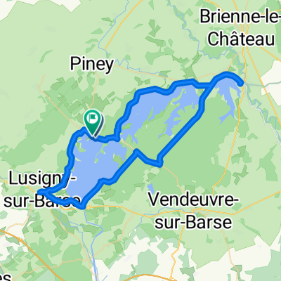
48.364, 4.334 naar 48.255, 4.269
A cycling route starting in Piney, Grand Est, France.
Overview
About this route
- 2 h 18 min
- Duration
- 24.5 km
- Distance
- 106 m
- Ascent
- 101 m
- Descent
- 10.7 km/h
- Avg. speed
- 156 m
- Max. altitude
Route photos


Continue with Bikemap
Use, edit, or download this cycling route
You would like to ride 48.364, 4.334 naar 48.255, 4.269 or customize it for your own trip? Here is what you can do with this Bikemap route:
Free features
- Save this route as favorite or in collections
- Copy & plan your own version of this route
- Sync your route with Garmin or Wahoo
Premium features
Free trial for 3 days, or one-time payment. More about Bikemap Premium.
- Navigate this route on iOS & Android
- Export a GPX / KML file of this route
- Create your custom printout (try it for free)
- Download this route for offline navigation
Discover more Premium features.
Get Bikemap PremiumFrom our community
Other popular routes starting in Piney
 2020-JR5-Lac du Der-Châlons-en-Champagne
- Distance
- 88.7 km
- Ascent
- 260 m
- Descent
- 323 m
- Location
- Piney, Grand Est, France
 Lake Round
- Distance
- 70.1 km
- Ascent
- 271 m
- Descent
- 271 m
- Location
- Piney, Grand Est, France
 lac du Temple + schiereiland
- Distance
- 17.2 km
- Ascent
- 38 m
- Descent
- 35 m
- Location
- Piney, Grand Est, France
 Route in Géraudot
- Distance
- 58.4 km
- Ascent
- 285 m
- Descent
- 285 m
- Location
- Piney, Grand Est, France
 Jour 6 : Troyes-Pontigny
- Distance
- 123.2 km
- Ascent
- 360 m
- Descent
- 327 m
- Location
- Piney, Grand Est, France
 Brévonnes à 9 Rue des Tilleuls, Puits-et-Nuisement
- Distance
- 24.5 km
- Ascent
- 404 m
- Descent
- 345 m
- Location
- Piney, Grand Est, France
 394 Petit Orient, Piney à D 443, Dienville
- Distance
- 25.2 km
- Ascent
- 194 m
- Descent
- 207 m
- Location
- Piney, Grand Est, France
- 48.364, 4.334 naar 48.255, 4.269
- Distance
- 24.5 km
- Ascent
- 106 m
- Descent
- 101 m
- Location
- Piney, Grand Est, France
Open it in the app