

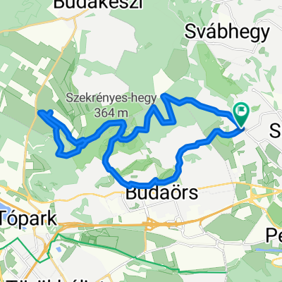
Kamaraerdő - Törökbálint - Biatorbágy - Kamaraerdő 39km
A cycling route starting in Budaörs, Pest megye, Hungary.
Overview
About this route
- 2 h 10 min
- Duration
- 38.6 km
- Distance
- 238 m
- Ascent
- 238 m
- Descent
- 17.9 km/h
- Avg. speed
- 195 m
- Max. altitude

Route quality
Waytypes & surfaces along the route
Waytypes
Quiet road
20.9 km
(54 %)
Cycleway
13.4 km
(35 %)
Surfaces
Paved
33.5 km
(87 %)
Unpaved
0.2 km
(<1 %)
Asphalt
33 km
(85 %)
Concrete
0.2 km
(<1 %)
Continue with Bikemap
Use, edit, or download this cycling route
You would like to ride Kamaraerdő - Törökbálint - Biatorbágy - Kamaraerdő 39km or customize it for your own trip? Here is what you can do with this Bikemap route:
Free features
- Save this route as favorite or in collections
- Copy & plan your own version of this route
- Sync your route with Garmin or Wahoo
Premium features
Free trial for 3 days, or one-time payment. More about Bikemap Premium.
- Navigate this route on iOS & Android
- Export a GPX / KML file of this route
- Create your custom printout (try it for free)
- Download this route for offline navigation
Discover more Premium features.
Get Bikemap PremiumFrom our community
Other popular routes starting in Budaörs
 Budai Tajvedelmi Körzet
- Distance
- 20.5 km
- Ascent
- 543 m
- Descent
- 544 m
- Location
- Budaörs, Pest megye, Hungary
 Tétényi-fennsík
- Distance
- 22.8 km
- Ascent
- 219 m
- Descent
- 239 m
- Location
- Budaörs, Pest megye, Hungary
 CBA - Velence
- Distance
- 58.1 km
- Ascent
- 545 m
- Descent
- 565 m
- Location
- Budaörs, Pest megye, Hungary
 From Budaörs to Velence
- Distance
- 57.1 km
- Ascent
- 473 m
- Descent
- 495 m
- Location
- Budaörs, Pest megye, Hungary
 Budai variáció
- Distance
- 29.1 km
- Ascent
- 858 m
- Descent
- 861 m
- Location
- Budaörs, Pest megye, Hungary
 Susulyka u. to Velence
- Distance
- 59 km
- Ascent
- 482 m
- Descent
- 494 m
- Location
- Budaörs, Pest megye, Hungary
 KFKI - SZEPJUHASZNE (Budaorsi Csiki-hegyek kitero)
- Distance
- 19.7 km
- Ascent
- 388 m
- Descent
- 480 m
- Location
- Budaörs, Pest megye, Hungary
 Unbenannte Route
- Distance
- 13.4 km
- Ascent
- 93 m
- Descent
- 48 m
- Location
- Budaörs, Pest megye, Hungary
Open it in the app