

Weißbach Seisenberg gorge part 2
A cycling route starting in Sankt Martin bei Lofer, Salzburg, Austria.
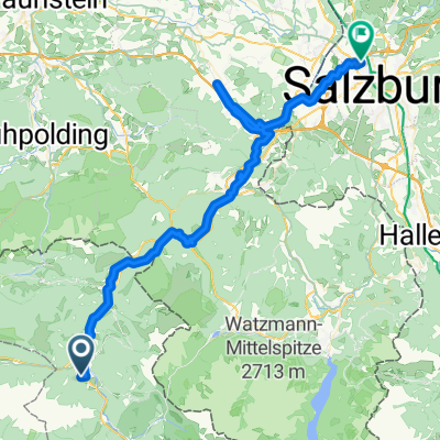
Overview
About this route
Special notes on the route The course is slightly hilly, a longer slope of about 1.5 km past the Ritzensee to overcome. ATTENTION: please also follow the diversion in the colour pink via the main road on the return journey.
- -:--
- Duration
- 33 km
- Distance
- 435 m
- Ascent
- 341 m
- Descent
- ---
- Avg. speed
- 826 m
- Max. altitude

Continue with Bikemap
Use, edit, or download this cycling route
You would like to ride Weißbach Seisenberg gorge part 2 or customize it for your own trip? Here is what you can do with this Bikemap route:
Free features
- Save this route as favorite or in collections
- Copy & plan your own version of this route
- Sync your route with Garmin or Wahoo
Premium features
Free trial for 3 days, or one-time payment. More about Bikemap Premium.
- Navigate this route on iOS & Android
- Export a GPX / KML file of this route
- Create your custom printout (try it for free)
- Download this route for offline navigation
Discover more Premium features.
Get Bikemap PremiumFrom our community
Other popular routes starting in Sankt Martin bei Lofer
 BGD-VNZ: 02 St. Martin - Saalbach (32 **, 33 **)
- Distance
- 31.5 km
- Ascent
- 1,090 m
- Descent
- 717 m
- Location
- Sankt Martin bei Lofer, Salzburg, Austria
 Sankt Martin bei Lofer, Grubhofsiedlung nach Pürzlbach, Weißbach bei Lofer
- Distance
- 19.9 km
- Ascent
- 1,027 m
- Descent
- 225 m
- Location
- Sankt Martin bei Lofer, Salzburg, Austria
 3A_ANGER
- Distance
- 63.8 km
- Ascent
- 871 m
- Descent
- 1,081 m
- Location
- Sankt Martin bei Lofer, Salzburg, Austria
 Hinterhorn von 1700 auf 2500m 6km
- Distance
- 6.1 km
- Ascent
- 1,735 m
- Descent
- 33 m
- Location
- Sankt Martin bei Lofer, Salzburg, Austria
 Steinbergrunde-Lang-RR
- Distance
- 82.5 km
- Ascent
- 938 m
- Descent
- 938 m
- Location
- Sankt Martin bei Lofer, Salzburg, Austria
 St.Martin -Hundsalm -
- Distance
- 25.1 km
- Ascent
- 901 m
- Descent
- 907 m
- Location
- Sankt Martin bei Lofer, Salzburg, Austria
 Lohfeyer- Hirschbichl - Dießbachstausee - Pürzlbach
- Distance
- 25.9 km
- Ascent
- 985 m
- Descent
- 985 m
- Location
- Sankt Martin bei Lofer, Salzburg, Austria
 Hirschbichl-Runde Diesbachstauee
- Distance
- 30.2 km
- Ascent
- 1,232 m
- Descent
- 1,232 m
- Location
- Sankt Martin bei Lofer, Salzburg, Austria
Open it in the app